Topic 2.7 Notes – Comparison of Economic Exchange
How Afro-Eurasian Trade Networks Expanded After 1200
All three networks grew because the same economic pattern was happening across Afro-Eurasia. Elites wanted luxury goods from far away, producers made more of them, and improved trade systems made exchange safer and cheaper.
- This was intensification, not creation. The routes already existed before 1200. The change was more volume, more distance, and more connections.
- Demand drove growth. Rulers and wealthy consumers wanted silk, porcelain, spices, precious metals, and fine textiles because these showed status and power.
- Regions specialized, which made long-distance exchange worth it:
- China exported silk, porcelain, and increased iron and steel production.
- India and Persia were known for textiles.
- Southeast Asia supplied spices.
- West Africa supplied gold.
- The Sahara supplied salt.
- Trade worked like a cycle. Demand led to more production, which led to more trade, which created more wealth, which created even more demand.
- These routes intersected. A good could move through more than one network before reaching its buyer. Spices from Southeast Asia might cross the Indian Ocean, then move through Middle Eastern and Mediterranean markets.
The map below pulls those links together. Focus on the overland Silk Roads in red and the sea routes in blue, since those are the main networks connecting East Asia, the Middle East, South Asia, and the Mediterranean.
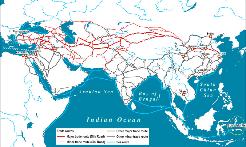
Afro-Eurasian trade routes after 1200
What All Three Networks Had in Common
Even though these routes crossed different environments, they expanded for very similar reasons.
- Commercial practices made trade easier:
- Caravanserai gave overland traders lodging, water, storage, and news.
- Bills of exchange and other credit let merchants avoid carrying all their money in coin.
- Banking houses and merchant-financiers loaned money and moved funds.
- Money economies expanded, especially paper money in Song and Yuan China.
- Tools and route knowledge worked together. A camel without desert guides was not enough. A compass without monsoon knowledge was not enough.
- States supported trade because they could tax it and profit from it:
- Pax Mongolica protected much of Eurasia.
- Mali controlled trade routes and gold fields.
- Swahili city-states, Gujarat, and Malacca protected and taxed Indian Ocean trade.
- Cities grew where trade concentrated wealth:
- Samarkand, Kashgar
- Kilwa and other Swahili ports
- Gao, Timbuktu
- More than goods moved:
- Islam spread through Indian Ocean and trans-Saharan merchants.
- Buddhism, Christianity, and Islam moved across Eurasia.
- Paper and gunpowder spread from China.
- Bananas spread in Africa; new rice varieties spread in East Asia.
- Bubonic plague traveled trade routes and became the Black Death.
- Social effects mattered too:
- Merchant classes got richer.
- More labor went into farming, mining, crafts, and transport.
- Export production changed gendered labor, especially in textiles.
- Merchant diasporas and enslaved people moved through these systems.
How Each Network Worked
Silk Roads
The Silk Roads were overland routes linking East Asia, Central Asia, the Middle East, and the Mediterranean.
- Trade depended on caravans, pack animals, caravanserais, and intermediary merchants.
- Key cities included Samarkand and Kashgar.
- Because land transport was expensive, this network favored high-value, low-bulk goods such as silk, porcelain, spices, precious metals, and horses.
- Pax Mongolica helped by making long-distance exchange across Eurasia safer and more integrated.
Indian Ocean network
The Indian Ocean system linked East Africa, the Middle East, India, Southeast Asia, and China. The map below highlights the major ports, sea-lanes, and seasonal monsoon pattern that made this network work.
- Trade relied on monsoon winds, compasses, astrolabes, larger ships, and port-to-port exchange.
- Major centers included Kilwa, the Swahili city-states, Gujarat, and Malacca.
- Ships could carry luxury and bulk goods, including spices, porcelain, textiles, rice, timber, and cotton cloth.
- Merchants often stayed abroad for months waiting for wind changes, which created diasporic communities.
- Zheng He’s voyages showed how a state could project power through this maritime network.
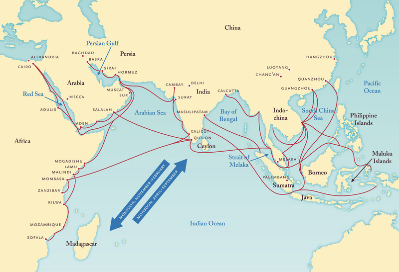
Indian Ocean trade routes and monsoon winds
Trans-Saharan routes
The trans-Saharan network linked West Africa to North Africa and the wider Islamic world.
- It depended on camels, improved camel saddles, caravans, oasis stops, and desert guides.
- Key cities included Gao and Timbuktu.
- Main goods were gold northward and salt southward, plus textiles, horses, manufactured goods, enslaved people.
- Mali became wealthy by controlling trade, and Mansa Musa’s pilgrimage showed both its gold wealth and Islamic connections.
Biggest Differences to Use in Comparisons
A strong comparison does more than list facts. It explains why the networks differed.
| Network | Geography | Cargo | Commercial organization | Political pattern |
|---|---|---|---|---|
| Silk Roads | deserts, steppes, mountains | mostly luxury goods | inland cities and intermediaries | Mongols were crucial |
| Indian Ocean | sea-lanes, winds, storms, ports | luxury + bulk goods | ports and diasporic merchants | no single unifying empire |
| Trans-Saharan | harsh desert, scarce water, oases | gold, salt, other valuable goods | caravans, oases, terminal markets | Mali and North African Muslim states mattered |
Transportation cost explains a lot. Ships carried far more than pack animals, so the Indian Ocean could move bulk goods. Overland and desert travel cost more and had greater limits, so the Silk Roads and trans-Saharan routes focused more on goods worth the trouble.
