Topic 4.1 Notes – Technological Innovations from 1450 to 1750
How Cross-Cultural Diffusion Made Transoceanic Sailing Possible
European expansion started with adaptation, not a brand-new invention. Long before Atlantic empires, sailors in the Mediterranean and Indian Ocean already knew how to travel long distances by sea.
- Earlier Afro-Eurasian trade networks spread more than goods. They also spread maps, mathematics, astronomy, instruments, and sailing practices.
- Classical learning contributed geography and astronomy, including the idea that location could be described with coordinates.
- Islamic scholars preserved and improved Greek knowledge. They advanced astronomy, mathematics, mapmaking, and navigational instruments, then passed that learning through trade and scholarship.
- Asian contributions mattered too, especially the magnetic compass, plus shipbuilding and sailing knowledge.
The core chain is this:
- Cross-cultural contact spread knowledge and technology.
- Europeans adapted those ideas for Atlantic use.
- Voyages became more reliable over long distances.
- Trade and travel expanded.
One continuity students forget is that long-distance maritime trade already existed. This map helps you see that older Afro-Eurasian network, especially the Mediterranean and Indian Ocean routes that connected Europe, Africa, the Middle East, India, and East Asia. Europeans entered an old world of sea trade and then linked it to the Atlantic and, later, the Americas.
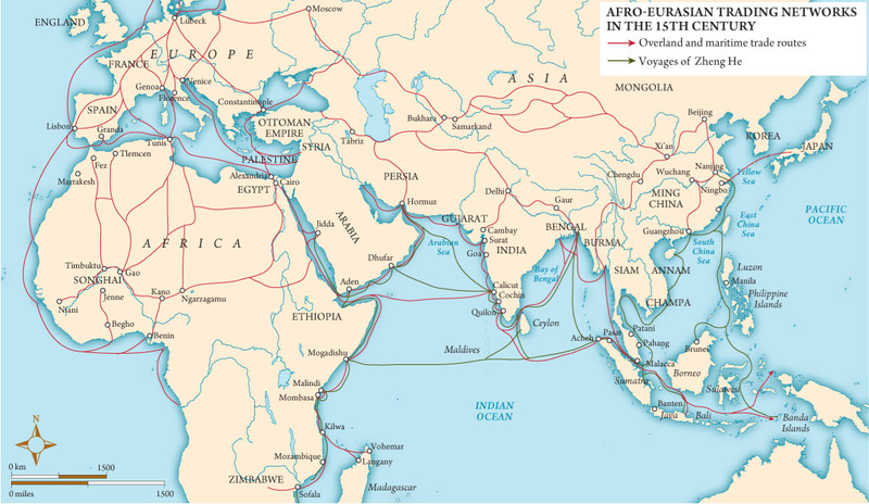
Afro-Eurasian trading networks in the 15th century
The Maritime System Europeans Put Together
No single tool explains expansion. Sailors needed several tools working together.
Navigation tools and knowledge
- Magnetic compass
Chinese in origin, spread west through exchange. It helped sailors keep direction in open water, at night, or under clouds. It did not tell exact location. - Astrolabe
Classical roots, refined in the Islamic world, adapted by Europeans into the mariner's astrolabe. It measured the angle of the sun or stars to estimate latitude. Related tools included the quadrant and cross-staff. - Charts and tables
Star tables and astronomical charts helped identify celestial bodies. Portolan charts mapped coastlines, ports, hazards, and compass directions. - Dead reckoning
Sailors estimated speed, direction, and distance traveled. This mattered because longitude was still very hard to calculate accurately.
Sailing and steering technology
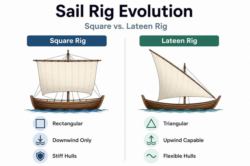
- Lateen sail
A triangular sail used widely in the Islamic Mediterranean and Indian Ocean. It improved maneuverability and allowed tacking, which means sailing at angles against the wind. - Square sails and mixed rigging
Square sails gave power with favorable winds. Combining square and lateen sails gave both speed and flexibility. - Sternpost rudder
Improved steering compared with older side-mounted steering oars. - Stronger hulls
Ships could carry more cargo, food, water, and weapons on long voyages.
The comparison below helps you see why Europeans valued mixed rigging on ocean-going ships.
The Main Ship Types
Different ships solved different problems.
| Ship | Best use | Key traits | Limitation |
|---|---|---|---|
| Caravel | Exploration | Small, fast, maneuverable, shallow draft | Limited cargo |
| Carrack | Long voyages and cargo | Large, deep-hulled, ocean-going, mixed rigging | Less maneuverable |
| Fluyt | Efficient trade | Dutch cargo ship, bulk transport, small crew | Built for commerce more than exploration |
- Caravel is tied to Portuguese and Spanish exploration, especially coastal reconnaissance.
- Carrack could carry more crew, provisions, and goods, so it fit long-distance commercial travel better.
- Fluyt lowered shipping costs and shows a later stage, when efficiency mattered as much as exploration.
How Winds and Currents Shaped Routes
Good tools only worked if sailors understood the ocean itself.
- In the Indian Ocean, merchants had long used monsoon winds. Europeans entering the region relied on that existing knowledge.
- In the Atlantic, trade winds pushed ships east-to-west in tropical areas, and westerlies helped them return eastward in higher latitudes.
- Currents also moved in broad recurring circuits.
The Atlantic map below highlights those repeating wind belts and current patterns that made long-distance sailing more predictable.
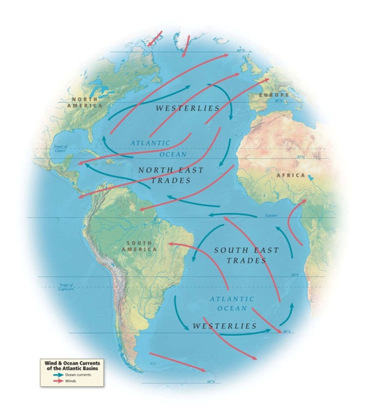
Atlantic wind belts and ocean currents
The best example is the Portuguese volta do mar. Ships returning from West Africa sailed far out into the Atlantic to catch better winds and currents before turning back to Europe. The route looked longer on a map, but it was faster in practice.
How These Innovations Changed Trade and Travel
These changes made sailing farther from shore more practical and predictable. Atlantic crossings became sustainable, cargo capacity grew, and regular trade became cheaper over time, especially with ships like the fluyt.
This connected existing Afro-Eurasian networks with the Americas. That connection later supported exploration, empire, and the Columbian Exchange, but those motives and consequences belong more to later topics. Here, the main point is simple. Europeans became major transoceanic powers by combining globally diffused knowledge into an effective maritime system.
Key Takeaways
Cross-Cultural Diffusion
Spread and adaptation of ideas and technologies between societies; it allowed Europeans to combine Classical, Islamic, and Asian maritime knowledge
Magnetic Compass
Chinese-origin navigational tool whose magnetized needle indicated direction, helping sailors maintain a heading when landmarks or celestial bodies were unavailable
Astronomical Charts and Tables
Star charts and recorded calculations used to identify celestial bodies and estimate a ship’s position, especially its latitude
Portolan Charts
Detailed Mediterranean maritime charts showing coastlines, ports, hazards, and networks of compass directions
Lateen Sail
Triangular sail widely used in the Islamic Mediterranean and Indian Ocean worlds that increased maneuverability and enabled ships to tack partly into the wind
Sternpost Rudder
Rudder mounted at a ship’s rear that improved steering over a side-mounted steering oar
Caravel
Small, fast, maneuverable Iberian vessel with a shallow draft and lateen or mixed rigging, especially useful for exploration and coastal reconnaissance
Carrack / Nau
Large, deep-hulled ocean-going vessel with multiple masts and mixed rigging that carried substantial cargo, provisions, crews, and weapons
Fluyt
Late-sixteenth-century Dutch cargo ship with a capacious hull and small crew that lowered shipping costs and efficiently carried bulk goods
Monsoon Winds
Seasonal Indian Ocean winds that reverse direction, allowing mariners to schedule dependable outward and return voyages
Trade Winds
Prevailing tropical winds that generally blow from east to west and helped determine Atlantic sailing routes
Westerlies
Prevailing winds in higher latitudes that generally blow from west to east and aided return voyages toward Europe
Volta do Mar
Portuguese “turn of the sea”: sailing west or northwest into the Atlantic before turning east to use favorable currents and westerlies on the return to Europe
Astrolabe
Classical instrument refined in the Islamic world and adapted for mariners to measure a celestial body’s altitude and estimate latitude
Square Sail
Sail effective for capturing following winds and providing substantial power on open-ocean voyages
Notes
Cross-Cultural Diffusion
Spread and adaptation of ideas and technologies between societies; it allowed Europeans to combine Classical, Islamic, and Asian maritime knowledge
Magnetic Compass
Chinese-origin navigational tool whose magnetized needle indicated direction, helping sailors maintain a heading when landmarks or celestial bodies were unavailable
Astronomical Charts and Tables
Star charts and recorded calculations used to identify celestial bodies and estimate a ship’s position, especially its latitude
Portolan Charts
Detailed Mediterranean maritime charts showing coastlines, ports, hazards, and networks of compass directions
Lateen Sail
Triangular sail widely used in the Islamic Mediterranean and Indian Ocean worlds that increased maneuverability and enabled ships to tack partly into the wind
Sternpost Rudder
Rudder mounted at a ship’s rear that improved steering over a side-mounted steering oar
Caravel
Small, fast, maneuverable Iberian vessel with a shallow draft and lateen or mixed rigging, especially useful for exploration and coastal reconnaissance
Carrack / Nau
Large, deep-hulled ocean-going vessel with multiple masts and mixed rigging that carried substantial cargo, provisions, crews, and weapons
Fluyt
Late-sixteenth-century Dutch cargo ship with a capacious hull and small crew that lowered shipping costs and efficiently carried bulk goods
Monsoon Winds
Seasonal Indian Ocean winds that reverse direction, allowing mariners to schedule dependable outward and return voyages
Trade Winds
Prevailing tropical winds that generally blow from east to west and helped determine Atlantic sailing routes
Westerlies
Prevailing winds in higher latitudes that generally blow from west to east and aided return voyages toward Europe
Volta do Mar
Portuguese “turn of the sea”: sailing west or northwest into the Atlantic before turning east to use favorable currents and westerlies on the return to Europe
Astrolabe
Classical instrument refined in the Islamic world and adapted for mariners to measure a celestial body’s altitude and estimate latitude
Square Sail
Sail effective for capturing following winds and providing substantial power on open-ocean voyages
