Topic 1.4 Notes – Spatial Concepts
What Spatial Concepts Are
Geography is not just naming places. It is explaining relationships among places. These concepts work like a chain:
- Location tells you where something is.
- Place tells you what that location is like.
- Space tells you how things are arranged and separated.
- Pattern shows the visible arrangement.
- Flows show movement between places.
- Distance decay explains why interaction usually weakens over distance.
- Time-space compression explains how technology can make far places feel closer.
A common AP move is this. First describe what you can see spatially on a map or in a scenario. Then explain why it exists.
Location, Space, and Place
These three get mixed up a lot, so keep their jobs separate.
Location
Absolute location is an exact position in a fixed reference system.
- Examples include latitude and longitude, a street address, or GPS coordinates.
- Standard example: Singapore is about 1.29° N, 103.85° E.
- If the prompt gives coordinates or an address, think absolute.
Relative location is where a place is compared with other places or routes.
- Singapore is near Malaysia and Indonesia and along major shipping routes.
- Other clues include words like near, between, along, central, peripheral, and accessible to.
- Relative location can change in importance if transportation or borders change, even though the absolute location stays the same.
Singapore is a good example because its importance comes from where it sits in relation to nearby states and the Strait of Malacca.
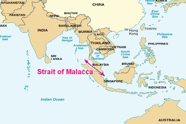
Singapore and the Strait of Malacca
Space
Space is about distance, separation, and arrangement.
- You can measure space in kilometers.
- You can also measure it by travel time, cost, barriers, or network access.
- Two places may be close on a map but effectively far apart because of mountains, borders, or weak infrastructure.
That “effectively far apart” idea shows up a lot in AP Human Geography.
Place
Place means a location with characteristics and meaning.
- Physical characteristics include climate, landforms, water, vegetation, soils, and elevation.
- Human characteristics include language, religion, architecture, economy, population, and politics.
- Sense of place means the feelings or meaning people attach to a location.
The same place can mean different things to different groups. A tourist, a migrant, and a government may all see the same city differently.
One easy distinction to remember: place is one distinctive location. Region is a larger area with shared traits.
Flows, Distance Decay, and Time-space Compression
Once you know where places are, geography asks how they connect.
Flows
Flows are movements between places. They show spatial interaction.
- Types of flows include people, goods, money, energy, information, ideas, culture, and political influence.
- Every flow has an origin, destination, direction, and often volume or frequency.
- Flows move through networks made of nodes and links.
- Nodes can be ports, airports, cities, or internet hubs.
- Singapore is a major shipping, aviation, and finance node.
On maps, arrows or lines usually show flows. Thicker lines often mean more movement, but always check the legend.
Distance decay
Distance decay means interaction usually drops as distance, time, or cost increases.
- The reason is friction of distance. More effort and expense reduce interaction.
- You see this in commuting, shopping, trade, museum visits, and even friendships.
- It is a tendency, not a law. People still travel far for specialized services or major cities.
The graph makes the pattern easy to see. Interaction starts highest at the origin and falls off quickly as distance increases.
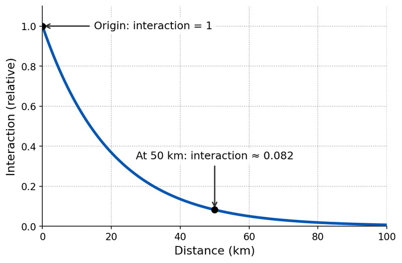
Distance decay graph
Time-space compression
Time-space compression happens when technology reduces the effective importance of distance.
- Examples include jet aircraft, container shipping, high-speed rail, fiber-optic cables, satellites, the internet, and mobile phones.
- This speeds up globalization because long-distance flows become faster and cheaper.
- It weakens some effects of distance decay, but does not erase them.
Limits still matter. Infrastructure is uneven, borders block movement, censorship restricts information, and income gaps affect access.
Spatial Patterns
Patterns are what you can actually see in the distribution of things across space.
The three main patterns
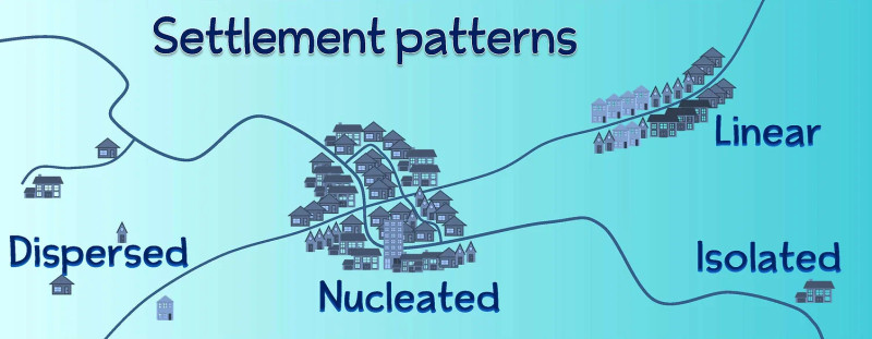
These settlement examples give you a quick visual of the big three patterns you need to recognize on maps.
- Clustered or agglomerated means features are concentrated together.
- Dispersed means features are spread out with noticeable separation.
- Linear means features follow a line such as a road, river, coast, rail line, or valley.
Settlement pattern examples
Describing patterns on maps
When you describe a pattern, stick to what is visible. You might see one dominant pattern, like the dispersed, nucleated, and linear examples shown here, or a mix of patterns in the same area.
- Name the main pattern.
- Note concentrations and gaps.
- Mention orientation, like north-south or along a coast.
- Say whether it follows a physical or human feature.
- Include exceptions, such as a clustered node inside a mostly linear pattern.
Scale matters. The same pattern can look clustered at one scale and dispersed at another.
Telling the Concepts Apart on the Exam
Use the clue in the wording:
- Exact coordinates or address = absolute location
- Compared to nearby places, routes, or hubs = relative location
- What makes a location distinctive = place
- Distance, separation, arrangement, accessibility = space
- Movement between places = flows
- Weaker interaction farther away = distance decay
- Faster or cheaper connection shrinking effective distance = time-space compression
- Arrangement of features = pattern
Key Takeaways
Absolute Location
A precise position stated within a fixed spatial reference system, such as coordinates or a street address
Relative Location
A position described in relation to other locations, routes, features, networks, travel times, or costs
Space
The physical extent containing geographic phenomena and the separation and arrangement among them
Place
A location given identity by its physical and human characteristics and the meanings associated with it
Flows
Movements of people, goods, money, resources, information, ideas, or influence between locations
Distance Decay
The general tendency for interaction between places to weaken as distance, travel time, or cost increases
Time-Space Compression
The reduced effective significance of distance caused by improvements in transportation and communication
Pattern (Spatial Pattern)
The observable arrangement of geographic phenomena across space
Clustered Pattern (Agglomeration)
A spatial pattern in which features are concentrated close together
Dispersed Pattern
A spatial pattern in which features are spread across an area with substantial separation
Linear Pattern
A spatial pattern in which features are arranged along a line or narrow corridor
Notes
Absolute Location
A precise position stated within a fixed spatial reference system, such as coordinates or a street address
Relative Location
A position described in relation to other locations, routes, features, networks, travel times, or costs
Space
The physical extent containing geographic phenomena and the separation and arrangement among them
Place
A location given identity by its physical and human characteristics and the meanings associated with it
Flows
Movements of people, goods, money, resources, information, ideas, or influence between locations
Distance Decay
The general tendency for interaction between places to weaken as distance, travel time, or cost increases
Time-Space Compression
The reduced effective significance of distance caused by improvements in transportation and communication
Pattern (Spatial Pattern)
The observable arrangement of geographic phenomena across space
Clustered Pattern (Agglomeration)
A spatial pattern in which features are concentrated close together
Dispersed Pattern
A spatial pattern in which features are spread across an area with substantial separation
Linear Pattern
A spatial pattern in which features are arranged along a line or narrow corridor
