Topic 4.5 Notes – The Function of Political Boundaries
What Political Boundaries Do
A political boundary marks the limit of authority over territory. It tells you where one government’s laws, taxes, services, and control end and another’s begin.
- International boundaries separate sovereign states.
- Internal boundaries divide one country into smaller units like states, provinces, counties, or municipalities.
You also need the vocabulary straight:
- Boundary means the legal line between jurisdictions.
- Border means the broader zone around that line, where crossings, trade, checkpoints, and cultural mixing happen.
- Frontier means an area of weak or unclear control, not a precise line.
Boundaries shape daily life. They control movement, trade, taxes, access to resources, and which government provides schools, police, and roads. Permeability matters here. An open boundary can still protect sovereignty while allowing travel and commerce. A closed or fortified one can sharply reduce migration, trade, and communication. On the exam, boundaries often work as either barriers or contact zones depending on policy.
How Boundaries Are Established and Managed
Boundaries do not appear all at once. They are made through four separate steps:
- Definition gives the legal description in a treaty, law, or ruling.
- Delimitation puts that legal boundary onto a map.
- Demarcation marks it on the ground with posts, fences, monuments, or buoys.
- Administration manages crossings, customs, migration, patrols, and upkeep.
The United States-Canada boundary is the classic example. The Convention of 1818 and Oregon Treaty of 1846 defined much of it, maps delimited it, surveyors and monuments demarcated it, and customs and immigration agencies still administer it.
Boundaries also reflect power. Some are negotiated. Others are imposed by war, colonialism, occupation, or unequal treaties. Even recognized boundaries can still be disputed over meaning, location, or resources.
Where Boundaries Come From and What They Divide
Many boundaries line up with cultural, national, or economic divisions. They may separate different languages, religions, ethnic groups, or economic systems. When a state and a nation line up closely, the boundary can strengthen national identity. But boundaries can also split one group across several states or force many groups into one state.
Economic contrasts across a boundary can be huge:
- different wages
- different taxes
- different currencies
- different labor laws
- different trade rules
That is why border cities can grow through cross-border exchange even when the countries have tense relations.
Berlin Conference
The Berlin Conference of 1884-1885 formalized European colonial claims in Africa. Many later African boundaries were imposed with little concern for ethnic territories or old trade networks. On an ethnic map, cultural regions often extend across those state borders. Those borders still became the sovereign borders of independent states later.
Demilitarized zones
A DMZ is a buffer zone with restricted military activity. The Korean DMZ, created by the 1953 armistice, separates North and South Korea and discourages interaction. Over time, that separation has reinforced distinct identities.
Types of Boundary Disputes
What matters on the test is identifying what exactly is being argued about.
| Dispute type | What is contested | Example |
|---|---|---|
| Definitional | treaty wording or meaning | Chile-Argentina in the Andes |
| Locational | where the line belongs or who controls territory | Kashmir |
| Operational | how the boundary functions | United States-Mexico migration and customs issues |
| Allocational | resources along or across the boundary | Iraq-Kuwait, river-water conflicts |
A quick way to sort them:
- wording = definitional
- placement/control = locational
- management = operational
- resources = allocational
Maritime Boundaries and Why Boundaries Matter
At sea, UNCLOS sets the main rules. This diagram gives you the basic maritime zones from the coastline outward.
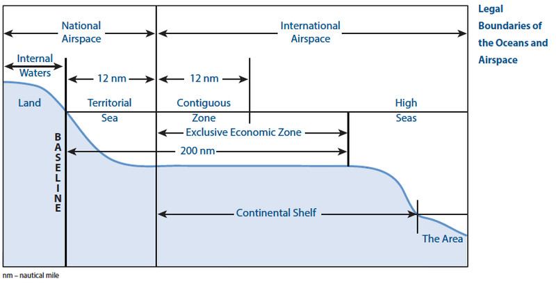
Major maritime zones under UNCLOS
- Territorial sea extends 12 nautical miles. The state has full sovereignty, though ships have innocent passage.
- Contiguous zone extends 24 nautical miles. The state has limited enforcement over customs, immigration, sanitation, and taxation.
- Exclusive economic zone extends 200 nautical miles. The state controls resource rights like fisheries, oil, gas, and seabed resources.
- High seas lie beyond national jurisdiction.
When coasts are less than 400 nautical miles apart, EEZs overlap. That can trigger disputes, often over fisheries, energy, islands, reefs, and shipping lanes. The South China Sea is the major example.
Boundaries matter at every scale. Locally they can divide families, farms, and ecosystems. Nationally they define citizenship and state power. Regionally and globally they shape trade, migration, security, shipping, and access to resources.
Key Takeaways
Political Boundary
The legally recognized line separating political jurisdictions and establishing the territorial limits of governmental authority
International Boundary
A boundary separating the territories and authority of sovereign states
Internal Boundary
A boundary dividing one sovereign state into subnational governmental or administrative jurisdictions
Border
A term used for a boundary line or, more broadly, the zone surrounding that line
Borderland
The zone around a boundary containing settlements, routes, cultural connections, and economic activities shaped by the border
Frontier
A zone where state control is weak, unclear, or still developing rather than a precisely established boundary line
Boundary Definition
The legal description of a boundary in a treaty, statute, ruling, or agreement
Boundary Delimitation
The cartographic placement of a legally defined boundary as a line on a map
Boundary Demarcation
The physical marking of a boundary with monuments, posts, signs, fences, buoys, walls, or cleared land
Boundary Administration
The continuing management of a boundary through enforcement, crossings, customs, maintenance, and dispute resolution
Sovereignty
A state's authority to govern its territory and conduct relations with other states
Berlin Conference
The 1884–1885 meeting that established rules for European colonial claims and accelerated the externally imposed partition of Africa
Demilitarized Zone (DMZ)
An area where military forces and installations are prohibited or restricted to separate opposing forces and reduce renewed conflict
Definitional Dispute
A boundary dispute over the wording or interpretation of the legal document that established the boundary
Locational / Positional / Territorial Dispute
A boundary dispute over where a line should be placed, which territory belongs to each side, or whether the line is legitimate
Operational / Functional / Administrative Dispute
A dispute over how an accepted boundary is managed, including migration, customs, policing, transportation, or barriers
Allocational / Resource Dispute
A dispute over ownership or use of resources located on, beneath, or across a political boundary
United Nations Convention on the Law of the Sea (UNCLOS)
The 1982 convention, in force since 1994, that establishes states' rights and responsibilities in maritime zones
Coastal Baseline
The coastal reference line, usually based on the low-water line, from which maritime zones are measured
Territorial Sea
Waters extending up to 12 nautical miles from the baseline where the coastal state exercises sovereignty, subject to innocent passage
Innocent Passage
The right of foreign ships to pass continuously and nonthreateningly through another state's territorial sea
Contiguous Zone
Waters extending as far as 24 nautical miles from the baseline where a state has limited customs, tax, immigration, and sanitation enforcement authority
Exclusive Economic Zone (EEZ)
A zone extending up to 200 nautical miles from the baseline where a coastal state has exclusive rights to manage natural resources
High Seas
Ocean areas beyond national maritime jurisdiction that are open to all states for lawful uses
International Waters
A common term for waters outside a state's territorial sea, including EEZs and the high seas despite their different legal rules
Notes
Political Boundary
The legally recognized line separating political jurisdictions and establishing the territorial limits of governmental authority
International Boundary
A boundary separating the territories and authority of sovereign states
Internal Boundary
A boundary dividing one sovereign state into subnational governmental or administrative jurisdictions
Border
A term used for a boundary line or, more broadly, the zone surrounding that line
Borderland
The zone around a boundary containing settlements, routes, cultural connections, and economic activities shaped by the border
Frontier
A zone where state control is weak, unclear, or still developing rather than a precisely established boundary line
Boundary Definition
The legal description of a boundary in a treaty, statute, ruling, or agreement
Boundary Delimitation
The cartographic placement of a legally defined boundary as a line on a map
Boundary Demarcation
The physical marking of a boundary with monuments, posts, signs, fences, buoys, walls, or cleared land
Boundary Administration
The continuing management of a boundary through enforcement, crossings, customs, maintenance, and dispute resolution
Sovereignty
A state's authority to govern its territory and conduct relations with other states
Berlin Conference
The 1884–1885 meeting that established rules for European colonial claims and accelerated the externally imposed partition of Africa
Demilitarized Zone (DMZ)
An area where military forces and installations are prohibited or restricted to separate opposing forces and reduce renewed conflict
Definitional Dispute
A boundary dispute over the wording or interpretation of the legal document that established the boundary
Locational / Positional / Territorial Dispute
A boundary dispute over where a line should be placed, which territory belongs to each side, or whether the line is legitimate
Operational / Functional / Administrative Dispute
A dispute over how an accepted boundary is managed, including migration, customs, policing, transportation, or barriers
Allocational / Resource Dispute
A dispute over ownership or use of resources located on, beneath, or across a political boundary
United Nations Convention on the Law of the Sea (UNCLOS)
The 1982 convention, in force since 1994, that establishes states' rights and responsibilities in maritime zones
Coastal Baseline
The coastal reference line, usually based on the low-water line, from which maritime zones are measured
Territorial Sea
Waters extending up to 12 nautical miles from the baseline where the coastal state exercises sovereignty, subject to innocent passage
Innocent Passage
The right of foreign ships to pass continuously and nonthreateningly through another state's territorial sea
Contiguous Zone
Waters extending as far as 24 nautical miles from the baseline where a state has limited customs, tax, immigration, and sanitation enforcement authority
Exclusive Economic Zone (EEZ)
A zone extending up to 200 nautical miles from the baseline where a coastal state has exclusive rights to manage natural resources
High Seas
Ocean areas beyond national maritime jurisdiction that are open to all states for lawful uses
International Waters
A common term for waters outside a state's territorial sea, including EEZs and the high seas despite their different legal rules
