Topic 4.6 Notes – Internal Boundaries
What Internal Boundaries Are
Internal boundaries divide territory within a sovereign state. They are different from international boundaries, which separate one country from another.
Different internal boundaries do different jobs:
- States or provinces divide power across major subnational units.
- Counties and municipalities organize local government and services.
- Autonomous regions can give certain groups more self-government.
- Legislative districts and city wards organize representation and elections.
These lines decide who governs where, who collects taxes, who provides services, and who represents people politically. That is why AP Human Geography treats boundaries as expressions of power, not just lines on a map. Some are negotiated, some imposed, and some tightly regulated by law.
Voting Districts and Why They Matter
A voting district or constituency is the area whose voters elect a representative. In the examples APHG uses most often, these are single-member districts, meaning one district elects one person.
Districting happens at several scales:
- Local: wards, school board districts, county districts
- Subnational: state legislative or provincial districts
- National: U.S. congressional districts, parliamentary constituencies
The key idea is simple. Election results depend on where voters are grouped, not just on total votes. A party can lose the statewide popular vote but still win more seats if its voters are spread efficiently across districts.
This congressional map is a good reminder that a national election can still be analyzed through many small district units.
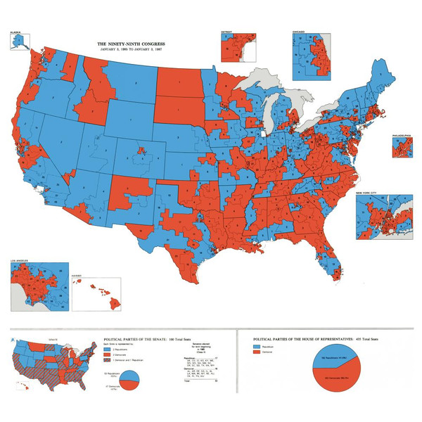
U.S. congressional districts
One exam trap is scale. A map can show the whole country but still be using district-level analysis if the units on the map are congressional districts.
Reapportionment, Redistricting, and Malapportionment
Population never stays still. People move to suburbs, cities grow, rural areas lose population, and birth rates differ. Over time, some districts end up much bigger than others.
That creates malapportionment, which means districts have unequal populations, so some voters get more representational weight than others.
In the U.S., census data every 10 years drives two related processes:
- Reapportionment redistributes the 435 U.S. House seats among states based on population. Every state gets at least one.
- Redistricting redraws district lines within a state or jurisdiction.
If a state gains or loses House seats, it must create or remove districts. Even if the number of seats stays the same, lines usually still change because people have shifted around. Senators are statewide, so they are not elected by district.
Common districting criteria:
- Equal population so votes have similar weight
- Contiguity so all parts of a district connect
- Compactness so a district is not stretched unnecessarily
- Respect for city/county boundaries
- Communities of interest kept together when possible
Redistricting is normal. It only becomes gerrymandering when lines are manipulated for advantage. State legislatures often draw maps, but some states use commissions, and courts can reject illegal maps.
Gerrymandering and Its Main Forms
Gerrymandering is deliberate district manipulation for political advantage. The name comes from Elbridge Gerry and the 1812 Massachusetts district compared to a salamander.
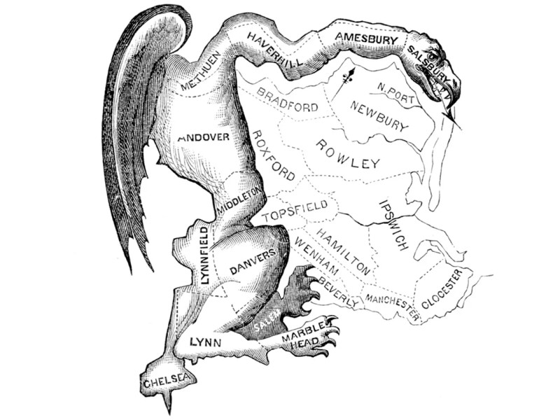
The original “Gerry-mander” cartoon
Packing
Packing concentrates the other side’s voters into a few districts they win by huge margins. Those extra votes are often called wasted votes because winning 80-20 does not earn more than one seat.
Cracking
Cracking splits an opposing group across several districts so it stays a minority in each.
These usually work together.
Main forms:
- Partisan gerrymandering helps a political party and often creates safe seats.
- Incumbent-protection gerrymandering protects current officeholders.
- Racial gerrymandering uses racial or ethnic settlement patterns to shape districts.
A majority-minority district is not automatically unfair. It can protect voting rights by giving a minority group a real chance to elect its preferred candidate. The issue is whether minority voters are being protected or overconcentrated.
Cases to know:
- Baker v. Carr and Wesberry v. Sanders support equal representation and “one person, one vote.”
- Shaw v. Reno deals with racial districting and oddly shaped majority-minority districts.
How to Read Gerrymandering on a Map and Its Effects
Shape can be a clue, but shape alone is not proof. Rivers, coastlines, city boundaries, and minority representation can also create odd shapes.
Better evidence combines several clues:
- voter blocs split apart = cracking
- opposition packed into a few districts = packing
- vote share vs seat share does not match well
- district populations are equal but outcomes still strongly favor one side
- precinct voting or demographic data under district lines
- alternative maps show a less biased option
A simple way to picture this is to compare a more balanced map with maps that pack voters into a few districts or crack them across many districts.
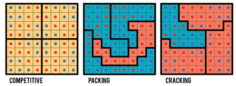
Packing and cracking patterns
Also remember natural packing. Urban voters may already be clustered, so a party can be overconcentrated even without intentional manipulation.
Political effects happen at every scale:
- Local: city council decisions on zoning, schools, policing
- State: control of taxes, education, infrastructure
- National: party control of Congress or parliament
Key Takeaways
Internal Boundary
A political division within a sovereign state that organizes territory into smaller governmental or electoral jurisdictions
Voting District / Electoral District / Constituency
A geographic area whose voters elect one or more representatives
Single-Member District System
An electoral system in which each geographic district elects one representative
Malapportionment
Substantially unequal district populations that give voters unequal representational weight
Reapportionment
Redistribution of legislative seats among larger territorial units according to population
Redistricting
The process of redrawing electoral district boundaries, usually to reflect population change or reapportionment
Contiguity
The districting criterion that all territory in a district be connected as one geographic unit
Compactness
The districting criterion that a district be reasonably concentrated rather than unnecessarily stretched or fragmented
Gerrymandering
Deliberate manipulation of electoral district boundaries to advantage a party, incumbent, or social group or weaken an opponent
Packing
Concentrating opposing voters into a small number of districts so they win those seats overwhelmingly but influence fewer districts
Cracking
Dividing a concentrated group among several districts so it remains a minority and cannot elect its preferred candidate in any of them
Partisan Gerrymandering
Drawing district boundaries to give a political party an electoral advantage
Incumbent-Protection Gerrymander
A district map designed to preserve the seats of current officeholders
Racial Gerrymandering
Manipulating district boundaries on the basis of racial or ethnic settlement patterns to alter a group’s electoral influence
Majority-Minority District
A district in which a racial or ethnic minority constitutes a majority of the relevant population
Notes
Internal Boundary
A political division within a sovereign state that organizes territory into smaller governmental or electoral jurisdictions
Voting District / Electoral District / Constituency
A geographic area whose voters elect one or more representatives
Single-Member District System
An electoral system in which each geographic district elects one representative
Malapportionment
Substantially unequal district populations that give voters unequal representational weight
Reapportionment
Redistribution of legislative seats among larger territorial units according to population
Redistricting
The process of redrawing electoral district boundaries, usually to reflect population change or reapportionment
Contiguity
The districting criterion that all territory in a district be connected as one geographic unit
Compactness
The districting criterion that a district be reasonably concentrated rather than unnecessarily stretched or fragmented
Gerrymandering
Deliberate manipulation of electoral district boundaries to advantage a party, incumbent, or social group or weaken an opponent
Packing
Concentrating opposing voters into a small number of districts so they win those seats overwhelmingly but influence fewer districts
Cracking
Dividing a concentrated group among several districts so it remains a minority and cannot elect its preferred candidate in any of them
Partisan Gerrymandering
Drawing district boundaries to give a political party an electoral advantage
Incumbent-Protection Gerrymander
A district map designed to preserve the seats of current officeholders
Racial Gerrymandering
Manipulating district boundaries on the basis of racial or ethnic settlement patterns to alter a group’s electoral influence
Majority-Minority District
A district in which a racial or ethnic minority constitutes a majority of the relevant population
