Topic 6.5 Notes – The Internal Structure of Cities
What the Internal Structure of Cities Is
The internal structure of a city means the spatial arrangement of land uses, transportation routes, economic activities, and social groups within one city or metro area. You’re working at the intracity scale here, not comparing separate cities the way central place theory or rank-size does.
What AP usually wants is simple but easy to miss. You identify the pattern, match it to the best model, and explain the force behind it.
Cities keep showing recurring patterns because of a few common forces:
- Accessibility matters because easy-to-reach land gives access to jobs, customers, services, and transport.
- Land value and land rent usually rise in central, accessible places because more groups want that land.
- Agglomeration means similar activities cluster together for mutual benefit, like finance firms near other business services.
- Incompatibility pushes some uses apart, like heavy industry and expensive housing.
- Transportation channels growth. Rail lines, ports, highways, airports, and beltways create corridors and nodes.
- Historical context leaves long-lasting marks. Industrialization, colonialism, segregation, suburbanization, and informal settlement all shape city form.
One caution you need in your head the whole time: models are simplified patterns, not exact maps. A real city can show more than one model at once.
Bid-Rent Theory
Bid-rent theory is the mechanism behind a lot of urban models. Different land users compete for space based on how accessible it is.
In a simple monocentric city, land value usually falls as you move away from the CBD. Different users bid differently:
- Commercial users pay the most near the CBD because they need visibility and customers.
- Industrial users need transport access and more land, so they often fit in intermediate zones.
- Residential users usually go farther out where land is cheaper and space is larger.
This explains why CBD land is built upward. When land is expensive, people use it intensely. It also explains why new nodes can form around airports, highway interchanges, and transit hubs in polycentric cities.
Limits matter too:
- zoning and public ownership can override the market
- segregation and environmental hazards distort the pattern
- prestige neighborhoods and gentrification can put wealthy residents near the center
North American Urban Models
These classic models are easiest to compare side by side because each one answers the same question in a different way. One uses rings, one uses sectors, and one uses multiple centers.
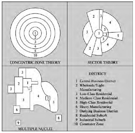
Classic North American urban models
Burgess concentric-zone model
Ernest Burgess based this on 1920s Chicago. In the left panel, the city is organized into one CBD with five rings:
- CBD
- Zone of transition
- Working-class homes
- Better residences
- Commuter zone
This fits an early industrial, monocentric city. Key processes are invasion and succession, filtering, and outward growth. Its weakness is that real cities do not grow in perfect rings.
Hoyt sector model
In the middle panel, Homer Hoyt kept one CBD but replaced rings with wedges. Industry and low-income housing extend along rail lines, rivers, or major roads. High-income housing grows along attractive corridors.
This model works when transportation routes shape land use. It still assumes one main center.
Harris and Ullman multiple-nuclei model
In the bottom-left panel, this model says large cities grow around several specialized nuclei such as a CBD, port, airport, university, industrial district, or suburban business district. Los Angeles is the classic example.
It fits large, decentralized, polycentric metros because some land uses cluster together and some stay apart.
Galactic city model
This is the post-World War II, car-based suburban metropolis. Think beltways, edge cities, office parks, shopping centers, and low-density sprawl. Joel Garreau popularized edge city, and Tysons Corner is the standard example.
It fits U.S. metros shaped by highways and suburbanization.
Regional Urban Models
North American models miss a lot when colonial history, informal land markets, and unequal land access matter more.
Latin American city model
The Griffin-Ford model has a strong CBD, a commercial spine, and an elite residential sector beside that spine. Farther out you see the zone of maturity, zone of in situ accretion, and peripheral informal settlements. Disamenity sectors occupy hazardous or undesirable land.
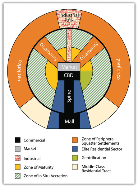
Latin American city model
Southeast Asian city model
The McGee model describes a port-oriented colonial city. It may not have one sharp CBD. Common pieces include an old port zone, government zone, commercial zone, mixed land use, high-income areas, newer industry, and peripheral informal settlements. Jakarta is the standard example.
African city model
Often linked to Harm de Blij, this model shows several central districts, a colonial CBD, traditional CBD, and market zone, plus ethnic neighborhoods, industrial districts, and peripheral informal settlements. Nairobi is the standard example.
How to Identify the Right Model on the Exam
Use the shape first, then explain the force behind it.
- One CBD + rings = Burgess
- One CBD + wedges/corridors = Hoyt
- Several specialized centers = Multiple nuclei
- Edge cities near highways or beltways = Galactic
- CBD + spine + elite sector + squatter settlements at edge = Latin American
- Port and colonial-commercial mix = Southeast Asian
- Colonial CBD + traditional CBD + market zone = African
Key Takeaways
Internal Structure of a City
The spatial arrangement of land uses, economic activities, transportation routes, and social groups within an urban area
Accessibility
The ease with which a location can be reached from other locations, affecting competition for urban land
Land Value vs. Land Rent
Land value is a location’s market value; land rent is the amount paid to occupy or use it
Agglomeration
The clustering of related activities to gain advantages from proximity
Central Business District (CBD)
The highly accessible concentration of a city’s commercial, financial, administrative, and entertainment functions
Bid-Rent Theory
Land users bid according to accessibility, so willingness to pay usually declines with distance from a center and the highest bidder occupies each location
Burgess Concentric-Zone Model
A monocentric industrial city arranged outward in rings: CBD, transition zone, working-class housing, better residences, and commuter zone
Invasion and Succession
The process by which a land use or social group expands into an adjacent urban zone and gradually replaces its occupants
Filtering
The transfer of older housing to lower-income households as wealthier households move to newer housing
Hoyt Sector Model
A monocentric model in which urban land uses form wedges extending from the CBD along transportation or amenity corridors
Harris and Ullman Multiple-Nuclei Model
A polycentric model in which specialized activities cluster around several nuclei because of facilities, agglomeration, incompatibility, and land costs
Galactic City Model (Peripheral Model)
A decentralized, automobile-oriented metropolis with peripheral nodes and edge cities connected by expressways and beltways
Edge City
A major concentration of offices, retail, entertainment, and employment outside the traditional downtown, usually near highway intersections
Latin American City Model (Griffin-Ford Model)
A model with a strong CBD, outward commercial spine and adjacent elite sector, with less secure or informal settlement toward parts of the periphery
Southeast Asian City Model
A port-oriented model with colonial, administrative, commercial, and mixed-use zones near the core rather than one sharply defined CBD.
African City Model
A model combining colonial and traditional CBDs, a market zone, ethnic and industrial districts, and peripheral informal settlement
Notes
Internal Structure of a City
The spatial arrangement of land uses, economic activities, transportation routes, and social groups within an urban area
Accessibility
The ease with which a location can be reached from other locations, affecting competition for urban land
Land Value vs. Land Rent
Land value is a location’s market value; land rent is the amount paid to occupy or use it
Agglomeration
The clustering of related activities to gain advantages from proximity
Central Business District (CBD)
The highly accessible concentration of a city’s commercial, financial, administrative, and entertainment functions
Bid-Rent Theory
Land users bid according to accessibility, so willingness to pay usually declines with distance from a center and the highest bidder occupies each location
Burgess Concentric-Zone Model
A monocentric industrial city arranged outward in rings: CBD, transition zone, working-class housing, better residences, and commuter zone
Invasion and Succession
The process by which a land use or social group expands into an adjacent urban zone and gradually replaces its occupants
Filtering
The transfer of older housing to lower-income households as wealthier households move to newer housing
Hoyt Sector Model
A monocentric model in which urban land uses form wedges extending from the CBD along transportation or amenity corridors
Harris and Ullman Multiple-Nuclei Model
A polycentric model in which specialized activities cluster around several nuclei because of facilities, agglomeration, incompatibility, and land costs
Galactic City Model (Peripheral Model)
A decentralized, automobile-oriented metropolis with peripheral nodes and edge cities connected by expressways and beltways
Edge City
A major concentration of offices, retail, entertainment, and employment outside the traditional downtown, usually near highway intersections
Latin American City Model (Griffin-Ford Model)
A model with a strong CBD, outward commercial spine and adjacent elite sector, with less secure or informal settlement toward parts of the periphery
Southeast Asian City Model
A port-oriented model with colonial, administrative, commercial, and mixed-use zones near the core rather than one sharply defined CBD.
African City Model
A model combining colonial and traditional CBDs, a market zone, ethnic and industrial districts, and peripheral informal settlement
