Topic 4.2 Notes – Political Processes
What Sovereignty and Nation-States Are
A state is a political unit with four core pieces you have to know together: a permanent population, defined territory, a government, and sovereignty, plus recognition by other states as an independent member of the international system. If one piece is missing, AP usually would not call it a fully functioning state.
Sovereignty means a state has authority over its land and people.
- Internal sovereignty means it can make and enforce laws inside its borders.
- External sovereignty means other states do not legally control it.
The Peace of Westphalia in 1648 is the classic starting point for the modern sovereign state system. It did not instantly create today’s world map, but it became the reference point for the idea that states control their own affairs.
A nation is different. It is a people with a shared identity tied to a homeland. That identity can come from language, ethnicity, religion, history, or culture.
- State = political territory
- Nation = identity group
- Nation-state = close match between one nation and one sovereign state
Exact nation-states are rare because people move, empires conquer, colonial powers draw borders, and many nations stretch across borders.
Nationalism is loyalty to a nation and the belief that it should have political expression. That often leads to self-determination, the idea that a people should choose its political status. That can mean representation, autonomy, independence, or union with a related state.
The tension you need to remember is this. One group’s self-determination can threaten another state’s sovereignty and territorial integrity.
Imperialism, Colonialism, and Boundary Making
Political boundaries did not appear naturally. Many were shaped by outside powers.
Imperialism is the broad extension of political, economic, military, or cultural power over other places. Colonialism is direct political control of a colony by an outside state. Every colony is imperialism, but imperialism does not always require direct rule.
Empires usually wanted several things at once:
- raw materials and farm goods
- markets and trade routes
- ports and military advantage
- prestige and rivalry
- land for settlers
- religion, language, and institutions to spread
European expansion reshaped the Americas, Africa, Asia, and Oceania. Africa is one of the clearest examples.
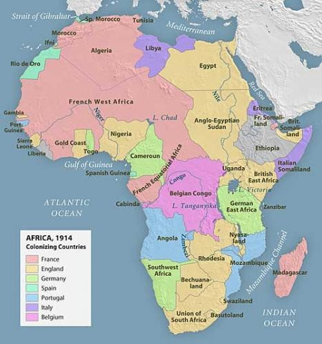
Africa under European colonial rule, 1914
The Berlin Conference of 1884 to 1885 is the standard example. European powers divided influence in Africa without African participation. That matters because many borders were drawn for imperial convenience, not to match nations.
The long-term effects show up again and again:
- one ethnic or language group split across borders
- several identity groups enclosed in one colony, then one state
- similar outside-made boundaries in former Ottoman lands after World War I through mandates
Independence Movements and Decolonization
Once colonial rule created these territories, nationalist movements pushed to take control of them.
An independence movement is an organized effort to end outside rule. Methods included protest, diplomacy, elections, strikes, and armed resistance. Decolonization is the larger process in which colonies become sovereign states.
The biggest wave came after World War II because European empires were weakened and anticolonial nationalism had grown.
Key examples:
- India, 1947 under British rule ends
- Ghana, 1957 becomes a major sub-Saharan example
- 1960 Year of Africa brings independence to 17 African states
- French Indochina and Algeria show violent decolonization
What often stayed the same after independence:
- colonial boundaries
- capitals and transport networks
- colonial languages
- legal and school systems
- export-based economies
That is a favorite AP point. Decolonization changed sovereignty more than boundaries.
India, Pakistan, and the Limits of Self-Determination
The clearest case study is the Partition of British India in 1947.
Pakistan was created in two separate parts, West Pakistan and East Pakistan, with India between them.
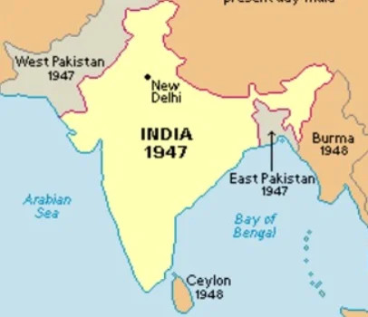
Partition of British India, 1947
The Muslim League wanted a separate Muslim homeland. Other leaders wanted one united independent state.
Because populations were mixed, partition did not create clean nation-states.
- about 14 million people migrated across the new borders
- mass violence hit Hindus, Muslims, and Sikhs
- minorities were left on both sides
- disputed territory led to long conflict
Bangladesh became independent in 1971. That shows religion alone did not hold Pakistan together. Language, region, and political power mattered too.
Devolution and the Breakup of States
Even after independence, states can still redistribute or lose power.
Devolution means power moves from the central government to regional or local governments. Along national lines, that usually gives authority to a territorially concentrated identity group.
Possible outcomes form a range:
- decentralization
- regional autonomy
- secession
- dissolution
The United Kingdom shows autonomy without independence through devolved power to Scotland, Wales, and Northern Ireland.
Other cases changed boundaries. The breakup of Yugoslavia is a key example to recognize on a map:
- Soviet Union dissolved in 1991 into 15 states
- Yugoslavia broke apart in the 1990s and 2000s; Kosovo declared independence in 2008 and is only partially recognized
- South Sudan seceded from Sudan in 2011
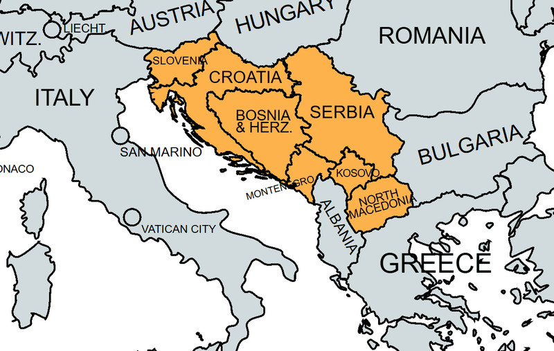
Former Yugoslavia and its successor states
A pattern connects the whole topic:
- imperialism and colonialism create boundaries
- nationalism grows
- self-determination drives independence
- decolonization creates sovereign states
- unresolved national differences can later produce autonomy, secession, or breakup
On maps, compare political borders to ethnic distributions. That helps you spot multinational states, divided nations, and colonial boundary legacies.
Key Takeaways
State
An organized political territory with a permanent population, defined territory, government, and sovereignty
Sovereignty
A state’s authority to govern its territory and population independently
Internal vs. External Sovereignty
Internal sovereignty is authority to make and enforce laws within a state; external sovereignty is independence from control by other states
Peace of Westphalia (1648)
A conventional starting point for the modern state system and the principle that territorial states govern their own internal affairs
Nation
A population united by a shared identity and attachment to a homeland
Nation-State
A sovereign state whose territory corresponds closely to the homeland and population of one nation
Nationalism
Loyalty to and identification with a nation, often including the belief that its interests should receive political expression
Self-Determination
The principle that a people sharing a common identity should help determine its own political status and government
Imperialism
The process by which a state extends political, economic, military, or cultural power over other territories and peoples
Colonialism
A form of imperialism in which an outside state directly controls a territory as a colony
Partition of Africa (Scramble for Africa)
The European conquest and division of most of Africa into colonies whose boundaries largely reflected imperial interests rather than African identities
Berlin Conference (1884–1885)
A meeting where European powers, without African participation, formalized rules that accelerated and regulated colonial expansion in Africa
Independence Movement
An organized effort to end foreign or imperial rule and establish self-government
Decolonization
The process by which colonial rule ends and a colony becomes an independent sovereign state
Partition of British India (1947)
The division of British India at independence into India and Pakistan, producing mass migration, violence, and new minorities because populations were intermixed
Devolution
The transfer of political authority from a central government to regional or local governments, sometimes along national lines
Secession
The removal of a territory from an existing state to create a new sovereign state
State Dissolution
The end of an existing state and its replacement by multiple successor states
Notes
State
An organized political territory with a permanent population, defined territory, government, and sovereignty
Sovereignty
A state’s authority to govern its territory and population independently
Internal vs. External Sovereignty
Internal sovereignty is authority to make and enforce laws within a state; external sovereignty is independence from control by other states
Peace of Westphalia (1648)
A conventional starting point for the modern state system and the principle that territorial states govern their own internal affairs
Nation
A population united by a shared identity and attachment to a homeland
Nation-State
A sovereign state whose territory corresponds closely to the homeland and population of one nation
Nationalism
Loyalty to and identification with a nation, often including the belief that its interests should receive political expression
Self-Determination
The principle that a people sharing a common identity should help determine its own political status and government
Imperialism
The process by which a state extends political, economic, military, or cultural power over other territories and peoples
Colonialism
A form of imperialism in which an outside state directly controls a territory as a colony
Partition of Africa (Scramble for Africa)
The European conquest and division of most of Africa into colonies whose boundaries largely reflected imperial interests rather than African identities
Berlin Conference (1884–1885)
A meeting where European powers, without African participation, formalized rules that accelerated and regulated colonial expansion in Africa
Independence Movement
An organized effort to end foreign or imperial rule and establish self-government
Decolonization
The process by which colonial rule ends and a colony becomes an independent sovereign state
Partition of British India (1947)
The division of British India at independence into India and Pakistan, producing mass migration, violence, and new minorities because populations were intermixed
Devolution
The transfer of political authority from a central government to regional or local governments, sometimes along national lines
Secession
The removal of a territory from an existing state to create a new sovereign state
State Dissolution
The end of an existing state and its replacement by multiple successor states
