Topic 5.2 Notes – Settlement Patterns and Survey Methods
What Rural Settlement Patterns and Survey Methods Are
A rural settlement pattern is the arrangement of houses, barns, and small communities in the countryside. A rural survey method is the cadastral system, which means the legal way land is measured, divided, and recorded into parcels.
The AP trick is keeping those separate. Buildings show the settlement pattern. Parcel boundaries show the survey method. A map can show both at once, but they are not the same thing.
Both patterns come from the same forces:
- Agriculture shapes how much land each farmer needs.
- Water and transportation pull buildings and parcels toward rivers and roads.
- Terrain limits where people can build.
- Landownership and culture affect whether people live together or separately.
- Government policy can impose a grid or preserve older claims.
- Old patterns often stay visible long after farming changes.
Types of Rural Settlement Patterns
Clustered settlements
Clustered or nucleated settlements put homes and buildings together in a village or hamlet, with fields around it.
- This often grows out of communal farming, shared wells or services, strong social ties, defense needs, or limited good land.
- Classic examples are traditional European villages and early New England villages around a common.
- On a map, look for a dense node of buildings surrounded by farmland.
Dispersed settlements
Dispersed or scattered settlements spread isolated farmsteads across the landscape. Farmers usually live on or near their own land.
- This fits places with abundant land, individual ownership, and mechanized or extensive farming.
- You see it across much of the U.S. interior and Canadian interior, especially in ranching areas.
- On a map, buildings appear separate from one another, with no clear village center.
Linear settlements
Linear settlements line buildings up along one feature such as a road, river, canal, coastline, levee, or valley floor.
- This happens when everyone wants access to water, transportation, fertile soil, or the only buildable strip of land.
- Good examples are along the St. Lawrence River in Quebec and the lower Mississippi in Louisiana.
- On a map, you see a ribbon of buildings with fields extending behind them.
Types of Rural Survey Methods
These three survey patterns show up clearly on maps, so it helps to compare them side by side before you learn the details.
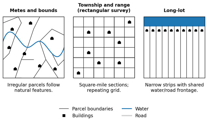
Rural survey methods
Metes and bounds
Metes and bounds describes land by tracing its edges from a starting point.
- Begin at a point of beginning.
- Follow directions and distances.
- Use landmarks like creeks, roads, trees, or stone walls.
- Return to the start.
This creates irregular parcels of different sizes. It is tied to English tradition and the eastern United States. On a map, look for uneven polygons that follow natural features. Weakness: landmarks can move or disappear, which causes disputes.
Township and range
Township and range, also called the rectangular survey system, was created by the Land Ordinance of 1785.
- Starts with a principal meridian and baseline
- Divides land into 6-mile by 6-mile townships
- Each township has 36 sections
- Each section is 1 square mile = 640 acres
- A quarter section is 160 acres
This creates a large repeating grid with straight roads and right-angle intersections, common in the central and western U.S.
Long lot
Long lot divides land into long, narrow strips set perpendicular to a river, road, or canal so each owner gets frontage on that resource.
It is associated with French settlement, especially Quebec and Louisiana. On a map, look for parallel narrow strips with buildings near the frontage and fields behind.
How Agriculture and Land Use Shape These Patterns
Agriculture explains why these patterns formed.
- Extensive farming and ranching need lots of land, so farms are farther apart and settlement is often dispersed.
- Intensive farming can support more people on less land, which can help produce clustered settlement.
- Individually owned parcels often lead farmers to live on their own land.
- Shared village farming encourages clustering.
- Water access can produce both long lots and linear settlement.
- Narrow valleys and riverbanks often create linear patterns.
- Plantations or estates may cluster worker housing, while family farms more often disperse residences.
How to Read the Pattern on the Exam
Start with this question in your head. Are you looking at buildings or parcel boundaries?
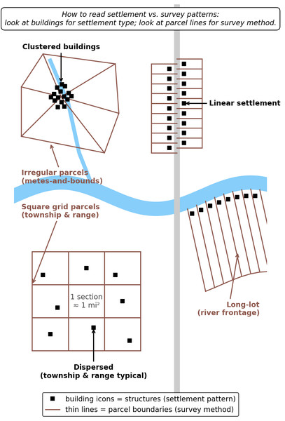
- Compact group of buildings = clustered
- Scattered isolated farmsteads = dispersed
- Ribbon of buildings along a road or river = linear
- Irregular feature-following parcels = metes and bounds
- Repeating square grid = township and range
- Long narrow strips perpendicular to water or road = long lot
That is exactly what the diagram is training you to separate. The black building symbols show settlement pattern, and the thin parcel lines show survey method.
Important connections:
- Township and range often goes with dispersed farms, but the grid is the survey method.
- Long lot often goes with linear settlement, but roads alone can also create linear settlement.
- Metes and bounds can exist with either clustered or dispersed settlement.
Key Takeaways
Clustered Settlement / Nucleated Settlement
A compact village or hamlet where homes and buildings are concentrated, generally with agricultural land extending outward
Dispersed Settlement / Scattered Settlement
Isolated farmsteads spread across the landscape, with households commonly living on or near the land they farm
Linear Settlement
Buildings arranged in a line or narrow band along a river, road, canal, coastline, or valley floor
Metes and Bounds
A survey method that traces a parcel using measured directions and distances called metes and identifiable boundary features called bounds, usually creating irregular parcels
Township and Range / Rectangular Survey System / Public Land Survey System
A grid survey based on principal meridians and baselines that divides land into 6-by-6-mile townships, each containing 36 one-square-mile sections
Long-Lot Survey / Long-Lot System
A survey method dividing land into long, narrow parcels perpendicular to a river, road, or canal so each owner receives frontage
Rural Settlement Pattern
The spatial arrangement of homes, farm buildings, and small communities in a rural landscape
Rural Survey Method / Cadastral System
A system for measuring, dividing, legally describing, and recording land parcels
Rural Land-Use Pattern
The arrangement of settlements, fields, pastures, roads, property boundaries, and other features associated with agriculture
Cadastral Pattern
The visible geometry of land-ownership parcels and their boundaries produced by a survey system
Notes
Clustered Settlement / Nucleated Settlement
A compact village or hamlet where homes and buildings are concentrated, generally with agricultural land extending outward
Dispersed Settlement / Scattered Settlement
Isolated farmsteads spread across the landscape, with households commonly living on or near the land they farm
Linear Settlement
Buildings arranged in a line or narrow band along a river, road, canal, coastline, or valley floor
Metes and Bounds
A survey method that traces a parcel using measured directions and distances called metes and identifiable boundary features called bounds, usually creating irregular parcels
Township and Range / Rectangular Survey System / Public Land Survey System
A grid survey based on principal meridians and baselines that divides land into 6-by-6-mile townships, each containing 36 one-square-mile sections
Long-Lot Survey / Long-Lot System
A survey method dividing land into long, narrow parcels perpendicular to a river, road, or canal so each owner receives frontage
Rural Settlement Pattern
The spatial arrangement of homes, farm buildings, and small communities in a rural landscape
Rural Survey Method / Cadastral System
A system for measuring, dividing, legally describing, and recording land parcels
Rural Land-Use Pattern
The arrangement of settlements, fields, pastures, roads, property boundaries, and other features associated with agriculture
Cadastral Pattern
The visible geometry of land-ownership parcels and their boundaries produced by a survey system
