Topic 6.4 Notes – The Size and Distribution of Cities
What an Urban System Is
This topic looks at cities in relation to each other, not land use inside one city. You’re looking at the whole settlement pattern across space.
Four ideas describe an urban system:
- Hierarchy means cities are ordered by population, functions, and influence. Small towns sit lower, regional cities sit in the middle, and major metros sit higher.
- Relative size means comparing one city’s population to others in the same country or region.
- Spacing means how far apart settlements are and how they’re arranged.
- Interdependence and interaction means cities are linked by flows of people, goods, services, money, and information.
Population and function usually go together, but not perfectly. A city can have huge political or economic influence without being the absolute largest.
A map of major U.S. freight and population centers helps show this last idea. Urban systems are not just a list of city populations. They also reflect how cities are connected through transportation and economic flows.
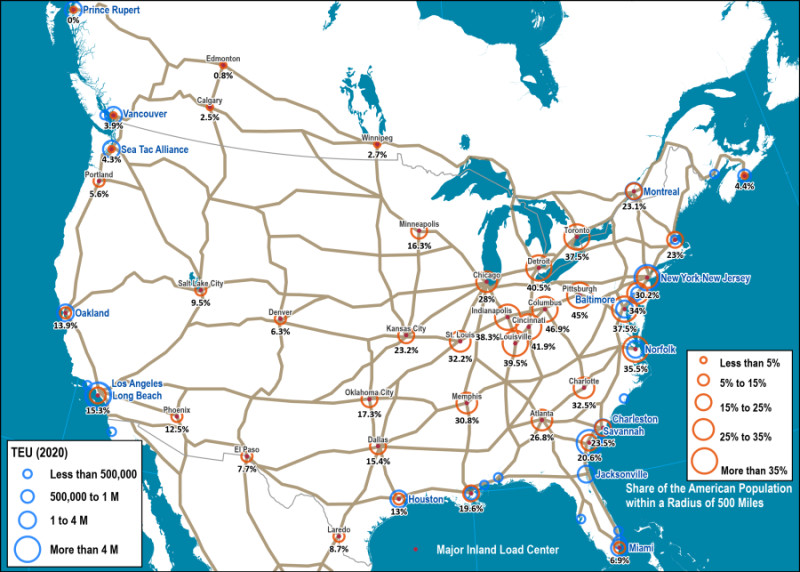
U.S. urban and freight network
One easy testing trap is boundaries. City proper, urbanized area, and metropolitan area can give different population totals, so rankings can change if the data uses different definitions.
Models of City Size and Distribution
Geographers use four main ideas here. Two describe city size, one predicts interaction, and one explains spacing and services.
Rank-size rule
The rank-size rule says the city ranked n should have the population of the largest city divided by n.
- If the largest city has 10 million people, the second should have about 5 million, the third about 3.3 million, and the fourth about 2.5 million.
- This suggests a balanced hierarchy with several important regional centers.
- The United States and Germany are often used as rough examples.
- On the AP exam, you usually compare actual populations to the expected pattern. Exact matches are not the point.
Primate city
A primate city is much larger and more influential than the rest of the cities in a country.
- It often dominates politics, transportation, media, education, and culture.
- It is not just the largest city.
- It is not always the capital.
- A strong clue is when the largest city is several times bigger than the second-largest.
- Standard examples include Bangkok, Paris, and London.
This is the opposite of rank-size. Rank-size shows a gradual drop. Primacy shows one city towering over the rest.
Gravity model
The gravity model predicts interaction between two places using population and distance.
- Bigger populations increase interaction.
- Greater distance reduces interaction.
- This can be used for trade, migration, commuting, travel, or communication.
- The key idea is distance decay. The farther apart places are, the weaker the interaction tends to be.
Central place theory
Central place theory, developed by Walter Christaller from southern Germany, explains the hierarchy, number, size, and spacing of settlements based on services.
- A central place provides goods and services to a surrounding hinterland or market area.
- The pattern is many small places, fewer medium places, and very few large ones.
The diagram shows the hexagonal market areas and the hierarchy of larger and smaller service centers that central place theory is trying to model.
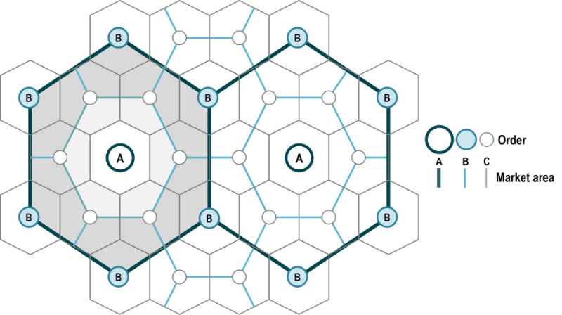
Central place theory diagram
How Central Place Theory Works
Two building blocks make the model work:
- Threshold is the minimum number of customers needed to support a service.
- Range is the maximum distance people will travel for that service.
Low-order and high-order goods fit those ideas:
| Type | What it’s like | Examples |
|---|---|---|
| Low-order | Cheap, common, bought often; low threshold and short range | convenience stores, basic groceries |
| High-order | Expensive, specialized, bought less often; high threshold and long range | specialized hospitals, universities, luxury retail |
That creates a pattern:
- Small towns are close together because people need everyday services nearby.
- Larger cities are farther apart because specialized services need more customers drawn from a wider area.
- Higher-order centers include both high-order and low-order services.
Christaller used hexagons because circles would overlap or leave gaps. Hexagons show complete coverage of space.
The model assumes flat land, even population and purchasing power, equal transportation in all directions, and consumers going to the nearest provider.
Why Real Cities Do and Do Not Fit the Models
Real geography bends the models. Colonial history, political centralization, transportation networks, migration, mountains, islands, and resource concentration can all create deviations.
Common causes of primacy include:
- centralized government
- a colonial export port or administrative center
- first-mover advantage
- transportation routes converging in one place
- concentration of universities, hospitals, and corporate offices
Primacy has benefits and costs:
- Benefits include agglomeration, strong labor markets, infrastructure, and a powerful national hub.
- Costs include regional inequality, congestion, housing shortages, environmental stress, and dependence on one city.
The gravity model also has limits. Borders, mountains, travel time, infrastructure, cultural ties, and intervening opportunities can weaken or redirect flows.
Central place theory also simplifies reality. Highways, coasts, rivers, uneven terrain, resources, government decisions, and online shopping all distort spacing.
Telling the Concepts Apart on the Exam
These questions usually signal the model for you:
- Comparing city population rankings across a country = rank-size rule or primate city
- One city overwhelmingly dominates national life = primate city
- Predicting flow between two cities = gravity model
- Explaining why small towns are numerous and large cities are farther apart = central place theory
- Talking about hinterlands, threshold, range, and service types = central place theory
- Talking about hierarchy, spacing, relative size, and interdependence together = urban system
Key Takeaways
Urban System
A network of settlements of different sizes and functions connected by flows of people, goods, services, money, information, and influence
Urban Hierarchy
The ordering of settlements by population, functions, and influence, from small towns to major metropolitan areas
Relative Size
The population of one city compared with the populations of other cities in the same urban system
Settlement Spacing
The distance and spatial arrangement among settlements
Spatial Interaction
The flows of people, goods, services, money, or information between places
Urban Interdependence
The mutual reliance of cities on one another and on their surrounding areas for workers, markets, goods, and services
Rank-Size Rule (Zipf’s Law)
A city-size pattern in which the nth-largest city has about 1/n the population of the largest city: Pₙ = P₁/n
Gravity Model
A model predicting that interaction increases with the populations of two places and decreases with distance, commonly Iᵢⱼ = PᵢPⱼ/dᵢⱼ².
Distance Decay
The tendency for interaction between places to weaken as distance increases
Christaller’s Central Place Theory
An ideal model explaining settlement size, number, hierarchy, and spacing through the distribution of goods, services, and market areas
Central Place
A settlement that provides goods and services to a surrounding market area
Market Area (Hinterland)
The surrounding area served by a central place and from which it draws customers
Threshold
The minimum number of customers, purchasing power, or demand needed to support a good or service
Range
The maximum distance consumers are willing to travel to obtain a good or service
Low-Order Goods and Services
Frequently purchased, relatively inexpensive goods and services with small thresholds and short ranges
High-Order Goods and Services
Infrequently purchased, specialized or expensive goods and services with large thresholds and long ranges
Primate City
A country’s disproportionately large and influential leading city that dominates major national functions
Urban Primacy
An urban pattern in which one city is disproportionately larger and more influential than the other cities in a country
Notes
Urban System
A network of settlements of different sizes and functions connected by flows of people, goods, services, money, information, and influence
Urban Hierarchy
The ordering of settlements by population, functions, and influence, from small towns to major metropolitan areas
Relative Size
The population of one city compared with the populations of other cities in the same urban system
Settlement Spacing
The distance and spatial arrangement among settlements
Spatial Interaction
The flows of people, goods, services, money, or information between places
Urban Interdependence
The mutual reliance of cities on one another and on their surrounding areas for workers, markets, goods, and services
Rank-Size Rule (Zipf’s Law)
A city-size pattern in which the nth-largest city has about 1/n the population of the largest city: Pₙ = P₁/n
Gravity Model
A model predicting that interaction increases with the populations of two places and decreases with distance, commonly Iᵢⱼ = PᵢPⱼ/dᵢⱼ².
Distance Decay
The tendency for interaction between places to weaken as distance increases
Christaller’s Central Place Theory
An ideal model explaining settlement size, number, hierarchy, and spacing through the distribution of goods, services, and market areas
Central Place
A settlement that provides goods and services to a surrounding market area
Market Area (Hinterland)
The surrounding area served by a central place and from which it draws customers
Threshold
The minimum number of customers, purchasing power, or demand needed to support a good or service
Range
The maximum distance consumers are willing to travel to obtain a good or service
Low-Order Goods and Services
Frequently purchased, relatively inexpensive goods and services with small thresholds and short ranges
High-Order Goods and Services
Infrequently purchased, specialized or expensive goods and services with large thresholds and long ranges
Primate City
A country’s disproportionately large and influential leading city that dominates major national functions
Urban Primacy
An urban pattern in which one city is disproportionately larger and more influential than the other cities in a country
