Topic 3.2 Notes – Cultural Landscapes
What Cultural Landscapes Are
A cultural landscape is the visible imprint of culture on the natural environment. You’re looking at what people did to space and what that says about them.
- Carl Sauer gave the classic idea. Culture acts on a natural landscape and transforms it into a cultural one.
- This means landscape is evidence. It shows beliefs, identity, resource use, power, and history.
- The built environment is only part of it. Cultural landscape also includes:
- fields and irrigation
- parcel boundaries
- roads and rail lines
- changed vegetation
- sacred sites
- toponyms or place names
- Physical geography matters because terrain, climate, water, and soils set limits and opportunities. But they do not fully decide outcomes. Two groups in similar environments can build different landscapes because of different technology, institutions, economies, and beliefs.
Parts of a Cultural Landscape
Landscapes mix natural settings with human choices, so you usually read several clues together.
Physical features and human modification
- Natural features like terrain, climate, water, soils, and vegetation form the setting.
- People reshape that setting through terraces, dams, drained wetlands, cleared forests, and filled coastlines.
- Bali’s rice terraces show this perfectly. Volcanic slopes and water made rice possible, but the terraces also reflect irrigation systems, Hindu water temples, and cooperative labor.
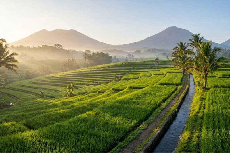
Bali rice terraces
Agricultural and industrial features
- Agricultural landscapes show culture through field shape and size, irrigation, fencing, farm buildings, crop choice, terracing, and settlement patterns.
- Industrial landscapes show culture through factories, mines, ports, rail lines, warehouses, worker housing, and pollution.
- The Ruhr region in Germany is a classic industrial landscape. Old mines and factories later became museums and parks, which shows changing values after deindustrialization.
Religious and linguistic features
Religion becomes visible in shrines, cemeteries, pilgrimage routes, sacred natural sites, and worship architecture.
- Jerusalem shows a layered sacred landscape because the same site holds meaning for multiple religions.
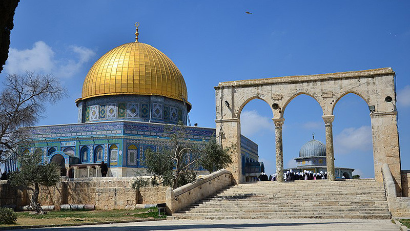
Jerusalem sacred landscape
- Language appears in signs, schools, monuments, and government notices.
- Toponyms preserve history and power. Santa Fe and San Francisco show Spanish and Catholic influence. Indigenous renaming or dual naming shows identity politics in the present.
Architecture and land-use patterns
Architecture shows how people use materials, respond to climate, and express values.
- Traditional and vernacular architecture reflects local materials, climate, and customs. Adobe and Pueblo architecture in the Southwest uses earth materials and fits hot, dry conditions.
- Modern architecture tends to be simple, functional, and built with steel, glass, and concrete.
- Postmodern architecture adds symbolism and historical references. The Portland Building is a classic example.
Land-use patterns include street plans, density, and property shapes.
| Parcel pattern | What it looks like | Where to know it |
|---|---|---|
| Rectangular survey system | regular grid | much of U.S. west of Appalachians |
| Long-lot system | long narrow parcels along rivers | French Louisiana, St. Lawrence |
| Metes and bounds | irregular parcels | older eastern areas |
Sequent occupancy
Sequent occupancy means successive groups leave layers on the same landscape, like a palimpsest.
- Older features may be reused, changed, or partly erased.
- Mexico City shows Mexica Tenochtitlan, Spanish colonial layers, and the modern metropolis all in one place.
How Landscapes Reflect Identity and Beliefs
Landscapes also show who belongs, who is excluded, and how groups organize daily life.
- Ethnicity appears through businesses, foodways, religious institutions, language, festivals, monuments, and housing patterns.
- An ethnic neighborhood has a concentration of one group. An ethnic enclave is more self-contained socially and economically.
- Ethnic concentrations grow through chain migration, support networks, discrimination, and clustered businesses.
- Little Havana in Miami shows Cuban identity through Spanish signs, Cuban businesses, and Calle Ocho.
- Indigenous landscapes reflect sacred ties to land, communal tenure, subsistence, and environmental management. Aboriginal cultural burning in Australia changed vegetation through controlled fire.
- Gender shapes space through labor divisions, land ownership, childcare locations, workplace patterns, and access to public or religious spaces. More women in the workforce can change commuting, services, and household organization.
Power, Conflict, and Reading the Landscape
Landscapes show power because governments, corporations, and dominant groups often decide what gets built, named, preserved, or removed.
- Contested landscapes include colonial monuments, redeveloped ethnic neighborhoods, and sacred sites claimed by multiple groups.
- Read visuals in this order:
- Identify concrete features.
- Describe the spatial pattern such as clustered, dispersed, linear, grid, irregular, boundary, or density change.
- Connect those features to a cultural belief, identity, institution, or historical layer.
- Explain how that factor shaped land use or space.
- Observation is what you can directly see. “Bilingual signs” is an observation.
- Inference is your conclusion from evidence. “The government recognizes a minority population” is an inference.
- Strong answers use multiple clues together, not one isolated feature.
Key Takeaways
Cultural Landscape
The physical environment together with the visible and spatial expressions of the cultures that have acted on it
Built Environment
The human-made portion of a cultural landscape, including buildings, roads, monuments, utilities, and other constructed features
Carl Sauer
Geographer who helped establish the approach that cultures transform natural landscapes into cultural landscapes
Agricultural Landscape
The visible arrangement of fields, crops, irrigation, farm structures, roads, and settlements created by agricultural practices
Industrial Landscape
The spatial pattern of factories, mines, warehouses, transportation, worker housing, power facilities, and other features associated with production
Sacred Landscape
A landscape whose places, features, organization, or land use carry religious significance
Toponym
A place name that can preserve evidence of language, religion, political authority, identity, or settlement history
Traditional Architecture
Architecture following forms and construction practices passed from one generation to another and associated with inherited customs
Vernacular Architecture
Architecture based on ordinary local building traditions, often using local materials and built without formally trained architects
Modern Architecture
Architecture emphasizing function, simplified geometric forms, limited ornament, and industrial materials such as steel, glass, and concrete
Postmodern Architecture
Architecture reacting against modernist uniformity by using ornament, symbolism, historical references, bright colors, or mixed traditions
Land Use
The organization of space for activities such as residence, agriculture, commerce, industry, transportation, worship, recreation, and conservation
Long-Lot System
A land-division system of long, narrow parcels extending from a river, road, or canal, giving many owners access to water and transportation
Metes and Bounds
A land-division system describing parcels through directions, distances, and landscape features, commonly producing irregular boundaries
Sequent Occupancy
Successive societies occupying and modifying the same place, each leaving cultural evidence that later groups preserve, alter, reuse, cover, or destroy
Ethnic Landscape
A landscape expressing ethnicity through settlement patterns, architecture, businesses, religion, foodways, festivals, monuments, language, or land use
Ethnic Neighborhood
An area containing a concentration of people, institutions, and businesses associated with a particular ethnic group
Ethnic Enclave
A concentrated ethnic social and economic community offering members employment, services, institutions, and support networks
Barrio
Spanish for neighborhood; in English-language geography it may mean a predominantly Latino neighborhood but not necessarily an impoverished district or ethnic enclave
Indigenous Landscape
A landscape shaped by an Indigenous people's long-standing territorial relationships, land management, subsistence practices, sacred sites, and ecological knowledge
Rectangular Survey System
A land-division system that creates a regular grid of roads, fields, and property boundaries; its U.S. form uses a township-and-range framework
Notes
Cultural Landscape
The physical environment together with the visible and spatial expressions of the cultures that have acted on it
Built Environment
The human-made portion of a cultural landscape, including buildings, roads, monuments, utilities, and other constructed features
Carl Sauer
Geographer who helped establish the approach that cultures transform natural landscapes into cultural landscapes
Agricultural Landscape
The visible arrangement of fields, crops, irrigation, farm structures, roads, and settlements created by agricultural practices
Industrial Landscape
The spatial pattern of factories, mines, warehouses, transportation, worker housing, power facilities, and other features associated with production
Sacred Landscape
A landscape whose places, features, organization, or land use carry religious significance
Toponym
A place name that can preserve evidence of language, religion, political authority, identity, or settlement history
Traditional Architecture
Architecture following forms and construction practices passed from one generation to another and associated with inherited customs
Vernacular Architecture
Architecture based on ordinary local building traditions, often using local materials and built without formally trained architects
Modern Architecture
Architecture emphasizing function, simplified geometric forms, limited ornament, and industrial materials such as steel, glass, and concrete
Postmodern Architecture
Architecture reacting against modernist uniformity by using ornament, symbolism, historical references, bright colors, or mixed traditions
Land Use
The organization of space for activities such as residence, agriculture, commerce, industry, transportation, worship, recreation, and conservation
Long-Lot System
A land-division system of long, narrow parcels extending from a river, road, or canal, giving many owners access to water and transportation
Metes and Bounds
A land-division system describing parcels through directions, distances, and landscape features, commonly producing irregular boundaries
Sequent Occupancy
Successive societies occupying and modifying the same place, each leaving cultural evidence that later groups preserve, alter, reuse, cover, or destroy
Ethnic Landscape
A landscape expressing ethnicity through settlement patterns, architecture, businesses, religion, foodways, festivals, monuments, language, or land use
Ethnic Neighborhood
An area containing a concentration of people, institutions, and businesses associated with a particular ethnic group
Ethnic Enclave
A concentrated ethnic social and economic community offering members employment, services, institutions, and support networks
Barrio
Spanish for neighborhood; in English-language geography it may mean a predominantly Latino neighborhood but not necessarily an impoverished district or ethnic enclave
Indigenous Landscape
A landscape shaped by an Indigenous people's long-standing territorial relationships, land management, subsistence practices, sacred sites, and ecological knowledge
Rectangular Survey System
A land-division system that creates a regular grid of roads, fields, and property boundaries; its U.S. form uses a township-and-range framework
