Topic 5.8 Notes – Von Thünen Model
What the Von Thünen Model Is
The von Thünen model is an economic model of rural land use. Johann Heinrich von Thünen, a German landowner and economist, published it in The Isolated State in 1826 to explain why farming patterns form around cities.
The core idea is simple. Distance from the market changes transportation cost, and transportation cost changes profit. Farmers do not just grow whatever they want wherever they want. They choose crops or livestock based on whether they can still make money after paying production costs and getting goods to market.
This is bid-rent theory, the same logic later applied to land use inside cities. Land closest to the market is most accessible, so it is also most expensive. That means only agricultural activities that earn a lot, or urgently need access, can afford inner land.
The APHG claim you need is this: intensive, perishable, or high-value agriculture tends to locate close to market, while extensive land uses tend to locate farther away. This is a model, not a literal map rule.
The Isolated State and the Four Rings
Von Thünen made extreme assumptions so distance would be the main variable.
- One central market city
- Flat land with the same fertility and climate in every direction
- No competing markets or outside trade
- No policy distortions or uneven transport routes
- Transportation cost rises with distance
That creates an isotropic surface, which just means conditions are the same in every direction. In the classic diagram, those equal conditions produce concentric rings around the central market.
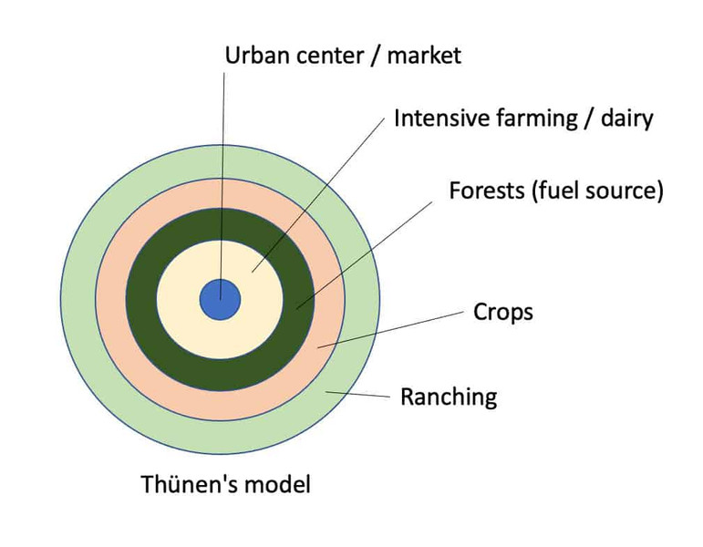
Von Thünen model
The four rings
Market gardening and dairying
- Fruits, vegetables, flowers, and milk go nearest the city.
- These are high-value, intensive, and often perishable, so farmers can pay high rent and need frequent delivery.
Forest
- Wood for fuel and construction was historically placed close in.
- Wood is bulky and heavy, so transport was expensive even though it was not perishable.
Field crops and grain
- Wheat and similar grains fit farther out.
- They are more durable, can be stored, and usually earn less per acre than inner-ring farming.
Livestock ranching
- Ranching uses lots of land and cannot afford expensive land near the city.
- Historically, animals could be walked to market “on the hoof,” which lowered transport cost.
Overall, land value and intensity decrease with distance, while extensive land use increases. Beyond the outer ring, farming is no longer profitable in the model.
How the Model Works
Transportation cost drives the whole pattern. Products differ in perishability, bulk, weight, value, and land needs, so distance hurts them differently.
The activity that earns the highest return at a location can outbid others for the land. Ring boundaries form where two activities could pay the same land rent.
A common exam trap is explaining everything with perishability. That only explains dairy and produce near the market. Forest is close because wood is heavy and bulky, and ranching is far away because it needs lots of cheap land and earns lower returns per acre.
As distance rises, land rent and profit fall because transportation costs rise.
Applying the Model at Different Scales
The clearest ring pattern works at the local scale, around one city.
At the regional scale, the model helps explain why high-value farming clusters near big metro markets, processors, or transportation hubs.
At the national scale, it becomes a broad analogy. In the United States, AP classes often use this pattern:
- Urban Northeast = market gardening and dairying
- Midwest = grain
- Farther West = ranching
That is not a perfect von Thünen map because the U.S. has multiple cities, railroads, environmental differences, and government policy.
The model also changes when transportation routes cut across the landscape. A river, road, or rail line can pull intensive land uses farther from the city because those locations stay well connected to the market.
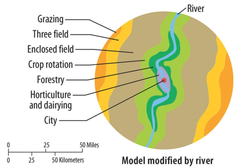
Von Thünen model modified by a river
Here, the farming zones stretch along the river instead of forming perfect circles. Accessibility matters more than straight-line distance.
Why the Model Matters and Why It Breaks Down
The model matters because it isolates situation factors like market access and transport cost from site factors like soil and climate. It also explains why better transportation can reshape agricultural regions.
Main limits
- Specialty farming often depends on site factors. Napa and Sonoma vineyards follow climate, soil, and clustering, not neat rings.
- Multiple markets and global trade break the one-city assumption.
- Roads, railways, rivers, and ports create corridors, not circles.
- Refrigeration, highways, and cold chains let perishable goods travel farther.
- Processing plants may matter more than final consumers.
- Government policy, subsidies, zoning, and culture can override the pattern.
- Urban sprawl can push farming away from cities.
Bottom line for the exam
If a question asks what the model explains, talk about distance from market, transportation cost, and land rent. If it asks why real places do not match, talk about uneven environments, multiple markets, transportation networks, technology, and specialty farming.
Key Takeaways
Von Thünen Model
Economic model in which transportation costs, market distance, and land rent produce zones of agricultural land use around a central market
Land Rent
The surplus an agricultural activity can pay for land after production and transportation costs; it generally declines with distance from the market
Bid-Rent Theory
Land users compete by offering rent, so the activity able to bid the most at a location is expected to occupy it
Isolated State
Von Thünen's hypothetical region with one market, uniform land and environment, equal transportation in all directions, and rational farmers maximizing returns
Market Gardening and Dairying Ring
The innermost ring, where perishable, intensive, high-return products can reach the market quickly and afford high land rents
Forest Ring
The second ring, located near the market because wood was heavy, bulky, and costly to transport in von Thünen's time
Field Crops and Grain Ring
The third ring, where durable crops needing more land and yielding less per unit of land can remain profitable farther from the market
Livestock Ranching Ring
The outermost productive ring, where ranchers use large areas of inexpensive land and historically drive animals to market on the hoof
Land-Rent Graph
A graph of rent against market distance in which the highest bid-rent line identifies land use and line intersections mark zone boundaries
Intensive vs. Extensive Agriculture
Intensive agriculture uses high inputs and often produces high value per unit of land, while extensive agriculture uses more land with lower inputs and output per unit; the model places intensive uses closer to markets
Site Factors vs. Situation Factors
Site factors are a location's physical conditions; situation factors are its position relative to markets and transportation routes
Specialty Farming
Agricultural production concentrated where particular environmental or other local conditions favor it, often disrupting von Thünen's predicted rings
Notes
Von Thünen Model
Economic model in which transportation costs, market distance, and land rent produce zones of agricultural land use around a central market
Land Rent
The surplus an agricultural activity can pay for land after production and transportation costs; it generally declines with distance from the market
Bid-Rent Theory
Land users compete by offering rent, so the activity able to bid the most at a location is expected to occupy it
Isolated State
Von Thünen's hypothetical region with one market, uniform land and environment, equal transportation in all directions, and rational farmers maximizing returns
Market Gardening and Dairying Ring
The innermost ring, where perishable, intensive, high-return products can reach the market quickly and afford high land rents
Forest Ring
The second ring, located near the market because wood was heavy, bulky, and costly to transport in von Thünen's time
Field Crops and Grain Ring
The third ring, where durable crops needing more land and yielding less per unit of land can remain profitable farther from the market
Livestock Ranching Ring
The outermost productive ring, where ranchers use large areas of inexpensive land and historically drive animals to market on the hoof
Land-Rent Graph
A graph of rent against market distance in which the highest bid-rent line identifies land use and line intersections mark zone boundaries
Intensive vs. Extensive Agriculture
Intensive agriculture uses high inputs and often produces high value per unit of land, while extensive agriculture uses more land with lower inputs and output per unit; the model places intensive uses closer to markets
Site Factors vs. Situation Factors
Site factors are a location's physical conditions; situation factors are its position relative to markets and transportation routes
Specialty Farming
Agricultural production concentrated where particular environmental or other local conditions favor it, often disrupting von Thünen's predicted rings
