Topic 6.6 Notes – Density and Land Use
What Residential Density and Residential Land Use Are
Residential density measures housing or residents on residential land.
That formula matters, but AP Human Geography usually cares more about what density looks like on the landscape.
- Residential land use means land used for housing. This topic stays with housing, not commercial or industrial land.
- Population density means people per area. That is broader than housing form.
- Housing density means dwelling units per area.
- Crowding means too many people inside living space. A place can be dense without being crowded.
- Building height does not automatically mean highest density. Widely spaced towers can be less dense than tightly packed rowhouses.
Low, medium, and high density are relative. What counts as high density in one metro area might feel ordinary in another. The main AP idea is that residential landscapes show culture, technology, development cycles, infilling, and power.
Low-, Medium-, and High-Density Housing
Low density
Low-density housing spreads households over more land.
- Detached single-family homes on separate lots
- Yards, setbacks, driveways, garages, cul-de-sacs
- Common in suburbs and metro fringes
- Usually tied to car dependence and separation from jobs and shopping
The standard example is postwar U.S. suburbanization. Highways, mortgage finance, mass car ownership, and single-family zoning helped create large low-density suburbs.
Medium density
Medium density fits more households in without relying on tall towers.
- Duplexes, triplexes, semidetached houses
- Townhouses, rowhouses or terraced houses
- Courtyard housing and low-rise apartments
- Smaller lots, attached walls, continuous street frontage
These often appear in older neighborhoods, transition zones, and transit corridors. Philadelphia, Baltimore, London, and Amsterdam are classic rowhouse examples. A tightly packed rowhouse district can reach substantial density even without skyscrapers.
A key test point is that rowhouses can be denser than tall buildings spaced far apart.
High density
High-density housing puts many households on little land, often through vertical building.
- Mid-rise and high-rise apartments or condos
- Many units per parcel
- Shared halls, elevators, and open space
- Little private yard space
You often see this near CBDs, transit stations, and major corridors because accessible land is expensive. Hong Kong is the standard example. Mountainous terrain limits buildable land, high land values push intense use, and rail transit plus elevator and steel construction make towers practical.
Why Density Varies Across a City
Cities do not have one single density. Density shifts because different parts of the city have different costs, access, and rules.
A classic way to visualize this is the bid-rent model, which shows why the most accessible land near the CBD tends to be used most intensively.
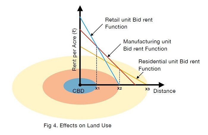
Bid-rent model of urban land use
- Accessibility and land value shape a density gradient. More accessible land costs more, so developers build more intensively there.
- Transportation changes form over time. Walking cities were compact. Streetcars and rail stretched growth along corridors. Cars and highways encouraged low-density sprawl. Transit today can support dense station-area housing.
- Physical geography matters. Mountains, wetlands, coasts, and limited buildable land can force density upward. Flat open land makes outward expansion easier.
- Zoning and regulation can block or allow density. Height limits, minimum lot sizes, setbacks, parking requirements, and multifamily bans directly shape what gets built.
- Development history leaves visible layers. Streetcar-era districts are often denser and more connected. Auto-era districts usually have detached homes, garages, and curving roads.
Infilling, Redevelopment, and Densification
These terms get mixed up a lot, so keep them separate.
- Infill means adding housing on vacant or underused land inside an already built-up area.
- Densification means increasing housing units or population within an existing area.
- Redevelopment means replacing or heavily changing an existing use. It can include infill, but they are not the same thing.
Ways density increases include apartments on empty lots, housing on old parking lots, dividing big homes into multiple units, adding accessory dwelling units, or replacing small buildings with larger multifamily ones. AP often contrasts this inward growth with outward fringe expansion.
What Density Reveals on Maps and in the Built Landscape
On maps and images, low density shows large lots, spacing, yards, and parking. Medium density shows attached walls, smaller parcels, and continuous blocks. High density shows many units, vertical form, and limited private open space.
Before interpreting data, check what the map actually measures. It might show persons per area, dwelling units per area, or building heights. Also check scale. A city average can hide huge neighborhood differences.
Density patterns show values about privacy, mobility, family life, and public space. They also show power through zoning, transit investment, preservation, and decisions to approve or block higher-density housing.
Key Takeaways
Residential Density
The number of dwelling units or residents per unit of residential land area
Housing Density
The number of dwelling units per unit of residential land
Building Density (Development Intensity)
The amount of building floor space occupying a parcel, which is not necessarily the same as residential density
Occupancy
The number of people living in each housing unit
Crowding
A condition in which too many people occupy too little interior living space; it is not the same as high residential density
Low-Density Residential Land Use
Relatively few households spread across substantial land, typically in detached single-family houses on large individual lots
Medium-Density Residential Land Use
More households per unit of land through attached houses, smaller lots, or low-rise multifamily buildings such as rowhouses and apartments
High-Density Residential Land Use
Many households concentrated on relatively little land, typically in mid-rise or high-rise multifamily buildings
Density Gradient
The tendency for residential density to be greatest near highly accessible urban locations and to decline with distance
Cycle of Development
The sequence in which an area is built, ages, experiences changing investment or demand, and is altered or redeveloped
Redevelopment
The replacement or substantial alteration of an existing land use or structure
Infill Development (Infilling)
New construction on vacant or underused land within an already substantially built-up urban area
Densification
The broader process of increasing the amount of housing or population accommodated in an existing area
Notes
Residential Density
The number of dwelling units or residents per unit of residential land area
Housing Density
The number of dwelling units per unit of residential land
Building Density (Development Intensity)
The amount of building floor space occupying a parcel, which is not necessarily the same as residential density
Occupancy
The number of people living in each housing unit
Crowding
A condition in which too many people occupy too little interior living space; it is not the same as high residential density
Low-Density Residential Land Use
Relatively few households spread across substantial land, typically in detached single-family houses on large individual lots
Medium-Density Residential Land Use
More households per unit of land through attached houses, smaller lots, or low-rise multifamily buildings such as rowhouses and apartments
High-Density Residential Land Use
Many households concentrated on relatively little land, typically in mid-rise or high-rise multifamily buildings
Density Gradient
The tendency for residential density to be greatest near highly accessible urban locations and to decline with distance
Cycle of Development
The sequence in which an area is built, ages, experiences changing investment or demand, and is altered or redeveloped
Redevelopment
The replacement or substantial alteration of an existing land use or structure
Infill Development (Infilling)
New construction on vacant or underused land within an already substantially built-up urban area
Densification
The broader process of increasing the amount of housing or population accommodated in an existing area
