Topic 4.4 Notes – Defining Political Boundaries
What Political Boundaries Are
A political boundary marks the limit of one political unit’s control. That unit might be a country, or it might be an internal division like a state, province, or city.
What geographers are asking here is not just “where is the line?” They’re asking four things about the line:
- When was it created compared to settlement and the cultural landscape?
- Did it follow or ignore existing cultural patterns?
- What shape does it take?
- Does it still function politically?
That’s why these labels can overlap. One boundary can be more than one type at the same time. On the exam, don’t classify from appearance alone unless the evidence is clearly about shape.
A historical map like this one helps show what geographers mean by a boundary as a political line on the landscape. Here, the proposed U.S.-Canada border is marked along the 49th parallel in the Pacific Northwest.
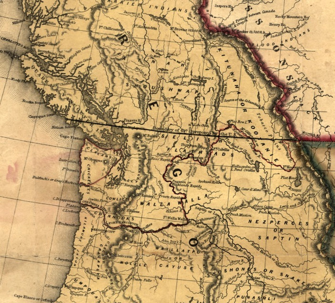
Historical map of the 49th-parallel boundary
The Six Boundary Types
These six types answer different questions, so keep the categories separate in your head.
Antecedent boundaries
An antecedent boundary is created before heavy later settlement or before the later cultural landscape develops. The line comes first, then people and settlement patterns grow around it.
- This does not mean the area was empty. Indigenous peoples may have already lived there.
- The usual example is much of the United States-Canada boundary along the 49th parallel, set by the Convention of 1818 and the Oregon Treaty of 1846.
Subsequent boundaries
A subsequent boundary is created after an area is already settled and culturally developed.
- It cuts through an existing landscape of communities, identities, and economic ties.
- Standard example: the boundary between Northern Ireland and the Republic of Ireland, created after partition in 1921.
Consequent boundaries
A consequent boundary is drawn to match an existing cultural division such as religion, language, ethnicity, or nationality.
- This is usually a specific kind of subsequent boundary.
- Standard example: Ireland’s partition broadly matching a Protestant/unionist northeast and Catholic/nationalist remainder.
Superimposed boundaries
A superimposed boundary is imposed by an outside or dominant power onto an existing cultural landscape, often ignoring local patterns.
- It may split one cultural group or force many groups into one state.
- Standard example: many African boundaries created during European imperialism, especially around the Berlin Conference of 1884-1885.
An ethnic map of Africa shows many small ethnic regions beneath modern state borders, which is exactly the pattern a superimposed boundary creates.
Geometric boundaries
A geometric boundary follows straight lines, latitude-longitude lines, or surveyed lines.
- It is based on math and mapping, not cultural or physical features.
- Standard example: the 49th parallel on the United States-Canada border.
- Also common in Africa and the Middle East.
Relict boundaries
A relict boundary is an old boundary that no longer works politically but still leaves traces on the landscape.
- Standard example: the former East-West Berlin division after German reunification in 1990.
- The old line survives in the route of the Berlin Wall, memorials, and urban differences.
This Berlin map highlights that former division and the wall route that remained meaningful even after the boundary stopped functioning politically.
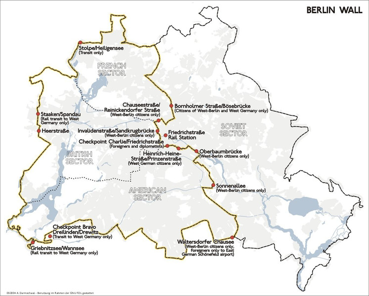
Berlin Wall and the former East-West division
The Key Pairs You Must Tell Apart
The hardest part is separating labels that sound similar.
- Antecedent vs. subsequent
- Antecedent = before later settlement/cultural development
- Subsequent = after settlement/cultural development
- The clue is timing
- Consequent vs. superimposed
- Consequent = follows existing cultural divisions
- Superimposed = cuts across or ignores them
- The clue is the boundary’s relationship to culture
- Geometric vs. the others
- Geometric describes shape
- A boundary can be geometric and antecedent, or geometric and superimposed
- Relict vs. active boundaries
- Relict means it no longer officially exists as a working political boundary
- An old boundary that still functions is not relict
How Boundary Classifications Overlap
Real boundaries often need two labels.
- United States-Canada 49th parallel
- Antecedent because it came before dense later settlement
- Geometric because it follows latitude
- Ireland and Northern Ireland
- Subsequent because the line came after settlement and cultural development
- Consequent because it broadly followed an existing religious and national divide
- African colonial boundaries
- Superimposed because Europeans imposed them on existing societies
- Often geometric because many are straight lines
- They can also be called subsequent, but superimposed is usually the better label
- Berlin
- When active, it was a functioning political boundary
- After reunification, it became relict
How to Identify the Right Type on the Exam
Use the evidence in this order:
- Does it still function politically?
- If no, but traces remain, it is relict.
- Is the clue about shape?
- Straight line, latitude, longitude, surveyed line = geometric
- Is the clue about timing?
- Before later settlement = antecedent
- After settlement = subsequent
- Is the clue about cultural divisions?
- Follows them = consequent
- Ignores them because an outside power imposed it = superimposed
FRQs love justification. Use the exact evidence they give you, such as colonial imposition, straight-line form, timing, cultural division, or visible landscape traces.
Key Takeaways
Political Boundary
A line marking the spatial limit of one political entity’s authority and the beginning of another’s
Antecedent Boundary
A boundary established before intensive settlement or the development of the area’s principal cultural landscape
Subsequent Boundary
A boundary established after an area has been settled and its cultural landscape has developed
Consequent Boundary
A boundary drawn to follow or accommodate an existing cultural division
Superimposed Boundary
A boundary imposed by an outside or dominant power on an existing cultural landscape without meaningful regard for local cultural patterns
Geometric Boundary
A boundary following a mathematically defined or surveyed line, such as latitude, longitude, or a straight segment
Relict Boundary / Relic Boundary
A former political boundary that no longer functions officially but remains visible in the cultural landscape
Notes
Political Boundary
A line marking the spatial limit of one political entity’s authority and the beginning of another’s
Antecedent Boundary
A boundary established before intensive settlement or the development of the area’s principal cultural landscape
Subsequent Boundary
A boundary established after an area has been settled and its cultural landscape has developed
Consequent Boundary
A boundary drawn to follow or accommodate an existing cultural division
Superimposed Boundary
A boundary imposed by an outside or dominant power on an existing cultural landscape without meaningful regard for local cultural patterns
Geometric Boundary
A boundary following a mathematically defined or surveyed line, such as latitude, longitude, or a straight segment
Relict Boundary / Relic Boundary
A former political boundary that no longer functions officially but remains visible in the cultural landscape
