Topic 1.2 Notes – Terrestrial Biomes
What Terrestrial Biomes Are
A terrestrial biome is a large land region defined by its climate and the biotic communities that climate supports. The two climate controls that matter most are temperature and precipitation, including how much rain falls and when it falls.
Climate shapes vegetation first. Then vegetation shapes animal life because plants provide:
- food
- shelter
- habitat structure
A biome is larger than an ecosystem. One biome can stretch across continents and include many separate ecosystems. Also, biome boundaries are not perfectly sharp. They often blend through ecotones, which are transition zones between biomes. Local factors like a mountain slope or wet valley can create exceptions.
The world map below helps you connect that idea to real geography. Notice that the same biome can appear on multiple continents because similar climate patterns support similar vegetation.
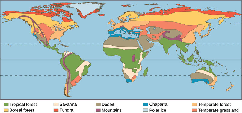
Global distribution of major terrestrial biomes
The Nine Major Terrestrial Biomes
Cold biomes
Tundra
Very cold and dry, with a short growing season. The key feature is permafrost, permanently frozen ground that blocks deep roots and prevents tree growth. Typical plants include mosses, lichens, grasses, and dwarf shrubs.Taiga or boreal forest
Long cold winters, short growing season, and low to moderate precipitation. Dominated by evergreen conifers such as spruce, fir, and pine. Soils are usually acidic and nutrient-poor.
Forest biomes
Temperate rainforest
Mild coastal climate with very high precipitation, fog, and dense tall forests, often conifer-dominated. High biomass.Temperate seasonal forest
Warm summers, cold winters, and moderate precipitation year-round. Dominated by deciduous trees such as oak, maple, beech, and hickory. Soils are fairly fertile.Tropical rainforest
Warm and wet year-round. Highest biodiversity, layered vegetation, and a closed canopy. A common test trap is that soil is often nutrient-poor even though plant growth is huge.
Grassland and shrub biomes
Shrubland or chaparral
Hot dry summers and mild wet winters. Dominated by drought-resistant shrubs and fire-adapted plants.Temperate grassland
Warm or hot summers, cold winters, and moderate to low precipitation. Grasses dominate, and soils are deep and fertile. Examples include prairies, pampas, steppes, and veld.Savanna
Warm year-round with distinct wet and dry seasons. Grasses with scattered trees. Maintained by drought, fire, and grazing.
Dry biome
Desert
Defined by aridity, not heat. Very low precipitation, sparse drought-adapted vegetation, and can be hot or cold.
Why Biomes Are Found Where They Are
Latitude creates the broad pattern because solar energy is highest near the equator and drops toward the poles. That gives you a general map pattern:
- Tropical rainforest near the equator
- Many deserts near north and south
- Temperate biomes in middle latitudes
- Taiga and tundra closer to the poles
Geography changes that pattern:
- Altitude lowers temperature, so mountains can shift biomes upslope.
- Rain shadows make windward slopes wetter and leeward slopes drier.
- Oceans moderate temperature and add moisture.
- Inland areas usually have bigger seasonal temperature swings.
The rain shadow effect is the mountain pattern shown here.
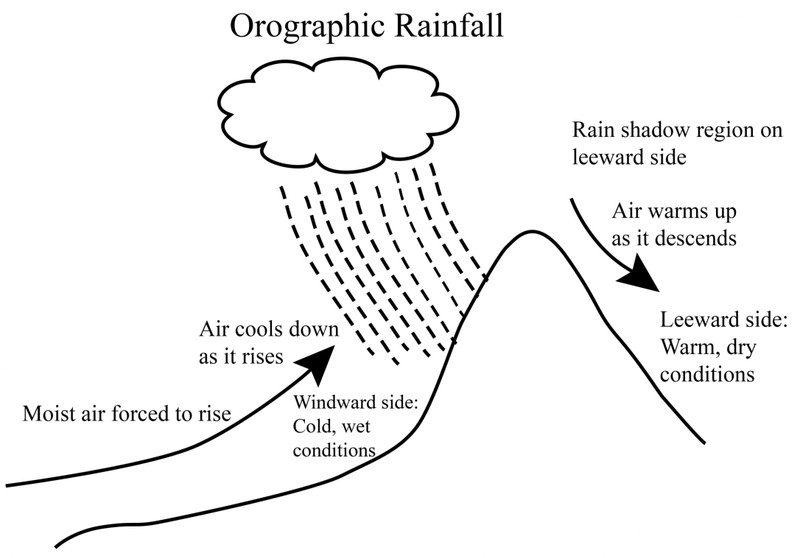
Rain shadow and orographic rainfall
Climate and soil also shape resources. Water is more available in wetter places, timber is concentrated in forests, and fertile farm soils are strongly tied to temperate grasslands. Tropical rainforests may have lots of biomass but still poor soil nutrients.
How to Identify and Compare Biomes
When you read a climatograph, use climate first and vegetation second.
- Check the overall temperature.
- Look at the annual temperature range.
- Check total precipitation.
- See whether precipitation is year-round or strongly seasonal.
- Match that pattern to likely vegetation.
Big distinctions that show up on tests:
- Tundra vs desert. Both are dry, but tundra is cold and often has permafrost.
- Tundra vs taiga. Taiga has coniferous trees. Tundra has no trees.
- Temperate rainforest vs tropical rainforest. Both are wet. Tropical rainforest stays warm all year.
- Tropical rainforest vs savanna. Both are warm. Savanna has a strong dry season.
- Savanna vs temperate grassland. Savanna is tropical with scattered trees. Temperate grassland has cold winters.
- Shrubland vs desert. Shrubland gets more seasonal rain and supports more woody plants.
A Whittaker biome diagram helps you connect those patterns to temperature and precipitation ranges.
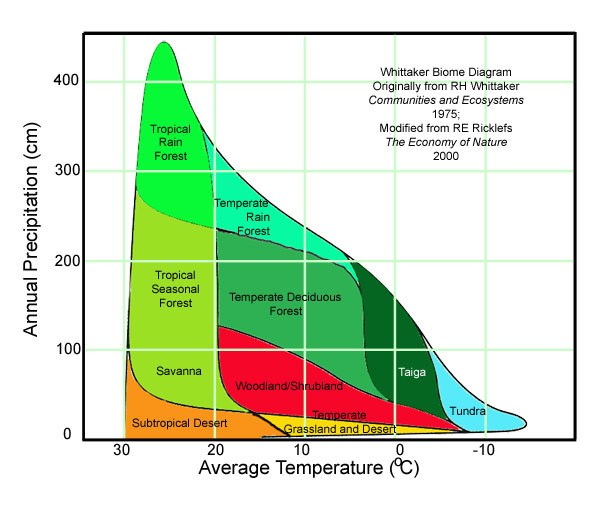
Whittaker biome diagram
Common mistakes:
- Choosing a biome from temperature alone
- Assuming all deserts are hot
- Assuming lush vegetation means fertile soil
Why Biome Distribution Can Change
Biome distribution is dynamic, which means it changes over time. Past climate changes shifted biomes poleward, equatorward, and upslope. Modern climate change can change temperature, precipitation, seasonality, and fire patterns too.
Likely results include:
- Tundra contraction
- Shifts among forest, grassland, and desert
- Changes in water and timber availability
One subtle point matters a lot. Species do not all move together, so a shifting biome may form messy transitional communities instead of one neat biome replacing another.
Key Takeaways
Terrestrial Biome
A large land region characterized by climate and by plant and animal communities adapted to that climate
Ecotone
A transition zone where adjacent biomes gradually blend into one another
Temperature-and-Precipitation Biome Diagram
A graph that uses mean annual temperature and precipitation to predict the likely biome of a location
Climatograph / Climate Diagram
A graph showing average monthly temperature as a line and average monthly precipitation as bars for a location
Tundra
A treeless, very cold biome with low precipitation, a short growing season, low vegetation, and often permafrost
Permafrost
Ground that remains frozen for at least two consecutive years, restricting drainage, deep roots, and tree growth
Taiga / Boreal Forest
A high-northern-latitude biome with long cold winters, short summers, and forests dominated by evergreen conifers
Temperate Rainforest
A cool to moderate coastal biome with mild temperatures, abundant precipitation, and tall, dense forests often dominated by conifers
Temperate Seasonal Forest / Temperate Deciduous Forest
A biome with four seasons, moderate year-round precipitation, and broadleaf trees that shed their leaves before winter
Tropical Rainforest
A warm, wet equatorial biome with layered evergreen vegetation, exceptionally high biodiversity, and often highly leached, nutrient-poor soil
Shrubland / Chaparral
A Mediterranean-climate biome with hot dry summers, mild rainy winters, fire, and drought-resistant woody shrubs
Temperate Grassland
A midlatitude interior biome with hot summers, cold winters, moderate to low precipitation, dominant grasses, and deep fertile soil
Savanna
A warm tropical grassland with scattered trees, a distinct wet season, a long dry season, and frequent grazing and fire
Desert
An arid biome where precipitation is extremely low relative to water loss, producing sparse, drought-adapted vegetation
Nonmineral Terrestrial Natural Resources
Land-based biological and water resources such as freshwater, timber, plant products, wildlife, and productive soil
Notes
Terrestrial Biome
A large land region characterized by climate and by plant and animal communities adapted to that climate
Ecotone
A transition zone where adjacent biomes gradually blend into one another
Temperature-and-Precipitation Biome Diagram
A graph that uses mean annual temperature and precipitation to predict the likely biome of a location
Climatograph / Climate Diagram
A graph showing average monthly temperature as a line and average monthly precipitation as bars for a location
Tundra
A treeless, very cold biome with low precipitation, a short growing season, low vegetation, and often permafrost
Permafrost
Ground that remains frozen for at least two consecutive years, restricting drainage, deep roots, and tree growth
Taiga / Boreal Forest
A high-northern-latitude biome with long cold winters, short summers, and forests dominated by evergreen conifers
Temperate Rainforest
A cool to moderate coastal biome with mild temperatures, abundant precipitation, and tall, dense forests often dominated by conifers
Temperate Seasonal Forest / Temperate Deciduous Forest
A biome with four seasons, moderate year-round precipitation, and broadleaf trees that shed their leaves before winter
Tropical Rainforest
A warm, wet equatorial biome with layered evergreen vegetation, exceptionally high biodiversity, and often highly leached, nutrient-poor soil
Shrubland / Chaparral
A Mediterranean-climate biome with hot dry summers, mild rainy winters, fire, and drought-resistant woody shrubs
Temperate Grassland
A midlatitude interior biome with hot summers, cold winters, moderate to low precipitation, dominant grasses, and deep fertile soil
Savanna
A warm tropical grassland with scattered trees, a distinct wet season, a long dry season, and frequent grazing and fire
Desert
An arid biome where precipitation is extremely low relative to water loss, producing sparse, drought-adapted vegetation
Nonmineral Terrestrial Natural Resources
Land-based biological and water resources such as freshwater, timber, plant products, wildlife, and productive soil
