Topic 4.6 Notes – Watersheds
What a Watershed Is
A watershed is the entire land area that drains surface water to one outlet. You may also see drainage basin or catchment. They mean the same thing.
That outlet could be:
- a point on a stream
- a river mouth
- a lake
- a reservoir
- an estuary
- the ocean
A watershed includes both the stream channels and the surrounding land feeding them. After precipitation falls, some water infiltrates into soil, some is stored or returned to the atmosphere by evaporation or transpiration, and some becomes surface runoff that flows downhill into channels.
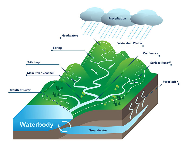
Watershed diagram
One easy idea that gets tested is that watersheds are nested. A small tributary watershed can sit inside a larger river watershed, which can sit inside a regional basin. The outlet you choose changes the watershed you’re talking about.
Parts of a Watershed
The water path through a watershed has a clear pattern.
- Headwaters are the upper reaches where streams begin, usually at higher elevation.
- Tributaries are smaller streams that flow into a larger one.
- The main channel is the main stream carrying water toward the outlet.
- A confluence is where two channels meet.
- The outlet is the discharge point, also called the pour point, where water leaves the watershed.
The edge of the watershed is the drainage divide. This is high ground, usually ridges, that separates adjoining watersheds. Rain falling on opposite sides of a divide drains to different outlets. A divide follows the high points, not the stream.
On maps, this matters a lot because students often draw boundaries along rivers. The boundary should wrap around the outside on the ridges. On topographic maps, contour lines bend into a V shape when they cross a stream valley, and the point of the V points uphill or upstream.
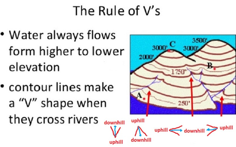
The rule of V's on a topographic map
Watershed Characteristics
These are the characteristics APES wants you to know.
- Area
Total land area inside the divide. Larger area usually means more potential runoff volume, but not faster runoff. - Length
Distance from the upper watershed or farthest headwaters to the outlet. This affects travel time and when discharge reaches the outlet. - Slope
Steeper slopes usually mean faster runoff, less time for infiltration, and more erosion. Gentle slopes usually slow runoff. - Soil
Soil affects infiltration and groundwater recharge.- Permeable soil lets water move through more easily, so immediate runoff is lower.
- Compacted or slowly permeable soil increases surface runoff.
- Porosity is space in soil. Permeability is how easily water moves through it. They are not the same.
- Saturated soil also increases runoff.
- Vegetation types
Vegetation intercepts rain, slows overland flow, increases infiltration, and holds soil in place with roots. Less vegetation usually means more runoff and erosion. - Divides with adjoining watersheds
These determine which outlet receives the runoff. Changes on one side affect that watershed, not the neighboring one.
How Water Moves Through a Watershed
Gravity moves water from high elevation to low elevation.
- Precipitation falls.
- Some infiltrates, evaporates, or is used by plants.
- Some becomes runoff and moves downslope.
- Runoff enters small channels.
- Small channels feed tributaries.
- Tributaries feed the main channel.
- Water reaches the outlet.
One high-value distinction is runoff amount vs runoff rate.
- Amount means the total quantity of water reaching the outlet.
- Rate means how quickly it gets there.
A large watershed can produce a lot of runoff, but it may respond slowly. A small, steep watershed with compacted soil and little vegetation may respond much faster.
Delineating and Using Watersheds
To delineate a watershed on a map, you trace the land draining to a chosen outlet.
- Locate the outlet.
- Trace the stream network upstream.
- Find the surrounding high ground.
- Follow ridges between valleys.
- Connect the high points into a closed boundary back to the outlet.
A good boundary encloses the drainage network and usually does not cross streams except at the outlet.
Watersheds matter because they connect Earth’s systems:
- atmosphere gives precipitation
- hydrosphere moves water
- geosphere shapes slope and soil
- biosphere affects infiltration and erosion through vegetation
Anything happening upstream can change the water, sediment, and other materials delivered downstream.
Key Takeaways
Watershed (Drainage Basin; Catchment)
The entire land area from which surface water drains to a common outlet, including the channels and surrounding runoff-contributing land
Subwatershed
A smaller drainage area feeding a tributary within a larger watershed
Headwaters
The upper, commonly high-elevation reaches where a stream or river system begins
Tributary
A smaller stream or river that flows into a larger one
Confluence
The location where two flowing channels meet
Outlet (Discharge Point; Pour Point)
The location through which water leaves the watershed being considered; the selected outlet determines the watershed's boundary and area
Drainage Divide (Divide)
A ridge or other high ground separating adjoining watersheds, with runoff on opposite sides flowing toward different outlets
Watershed Area
The total land area enclosed by the drainage divide and draining to the selected outlet
Watershed Length
The approximate distance from the upper watershed or most distant headwaters to the outlet, which influences runoff travel time and discharge timing
Watershed Slope
The change in elevation over horizontal distance; steeper slopes generally produce faster runoff and greater erosion
Watershed Delineation
Starting at a specified outlet, trace upstream channels, identify surrounding high ground, and connect the ridges into a closed drainage-divide boundary
Notes
Watershed (Drainage Basin; Catchment)
The entire land area from which surface water drains to a common outlet, including the channels and surrounding runoff-contributing land
Subwatershed
A smaller drainage area feeding a tributary within a larger watershed
Headwaters
The upper, commonly high-elevation reaches where a stream or river system begins
Tributary
A smaller stream or river that flows into a larger one
Confluence
The location where two flowing channels meet
Outlet (Discharge Point; Pour Point)
The location through which water leaves the watershed being considered; the selected outlet determines the watershed's boundary and area
Drainage Divide (Divide)
A ridge or other high ground separating adjoining watersheds, with runoff on opposite sides flowing toward different outlets
Watershed Area
The total land area enclosed by the drainage divide and draining to the selected outlet
Watershed Length
The approximate distance from the upper watershed or most distant headwaters to the outlet, which influences runoff travel time and discharge timing
Watershed Slope
The change in elevation over horizontal distance; steeper slopes generally produce faster runoff and greater erosion
Watershed Delineation
Starting at a specified outlet, trace upstream channels, identify surrounding high ground, and connect the ridges into a closed drainage-divide boundary
