Topic 4.5 Notes – Global Wind Patterns
What Global Wind Patterns Are
Global wind patterns are the large-scale, persistent movement of air in the atmosphere. They exist because the equator gets the most intense solar radiation, so Earth is heated unevenly.
Here’s the chain you need to know cold:
- Unequal heating causes temperature differences
- Temperature differences cause density differences in air
- Density differences create pressure differences
- Pressure-gradient force moves air from high pressure to low pressure
- Earth’s rotation causes Coriolis deflection, which bends that moving air
That last part gets tested a lot. Pressure differences directly cause wind. The Coriolis effect changes wind direction, but it does not start the wind.
This circulation matters because it moves heat from the equator toward the poles and helps redistribute water vapor, which affects rainfall patterns.
The Pressure Belts, Convection Cells, and Wind Belts
There are six major circulation cells total, with three in each hemisphere. The key latitude bands are approximate: 0°, 30°, 60°, and 90°.
This global circulation diagram pulls those pressure belts, convection cells, and wind belts together in one view.
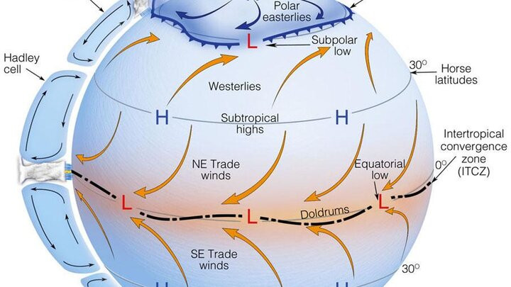
Global pressure belts
- 0° equatorial low pressure
Strong heating makes air rise. Rising air means low pressure, clouds, and lots of precipitation. - About 30° subtropical high pressure
Air sinks here. Sinking air means high pressure, divergence, and drier conditions. - About 60° subpolar low pressure
Air rises again, so this zone often has active weather. - 90° polar high pressure
Very cold, dense air sinks at the poles.
Two named regions show up a lot:
- ITCZ or Intertropical Convergence Zone sits near the equator, where trade winds meet and air rises.
- Doldrums are the weak, variable winds near the ITCZ.
- Horse latitudes are the subtropical high-pressure zones near 30°.
The three-cell model
- Hadley cells from 0° to 30°
- Air rises at the equator
- Moves poleward high in the atmosphere
- Cools and sinks near 30°
- Surface air returns toward the equator
- Ferrel cells from 30° to 60°
- Surface air moves toward 60°
- Air rises near 60°
- Returns aloft toward 30°
- This cell is less directly caused by heating than the other two
- Polar cells from 60° to 90°
- Cold air sinks at the poles
- Surface air moves toward 60°
- Air rises near 60° and returns poleward aloft
Prevailing surface wind belts
- Trade winds from 30° to 0°
- Northeast trade winds in the Northern Hemisphere
- Southeast trade winds in the Southern Hemisphere
- Overall east-to-west flow toward the ITCZ
- Prevailing westerlies from 30° to 60°
- Blow from the west
- Overall west-to-east movement
- Polar easterlies from 60° to 90°
- Blow from the east
- Overall east-to-west movement
How Atmospheric Circulation Happens
This whole system works in a clear sequence:
- The equator receives the most intense solar radiation.
- Earth’s surface heats the air above it.
- Warm air expands, becomes less dense, and rises.
- Rising and sinking air create bands of low and high pressure.
- Surface air moves from high pressure toward low pressure.
- Earth’s rotation deflects that motion through the Coriolis effect.
- The result is organized wind belts and convection cells.
A common mistake is mixing up temperature and pressure. Temperature differences help create the pattern, but pressure differences are what directly move the air.
How the Coriolis Effect Changes Wind Direction
Earth rotates west to east, so moving air appears to curve on a rotating planet.
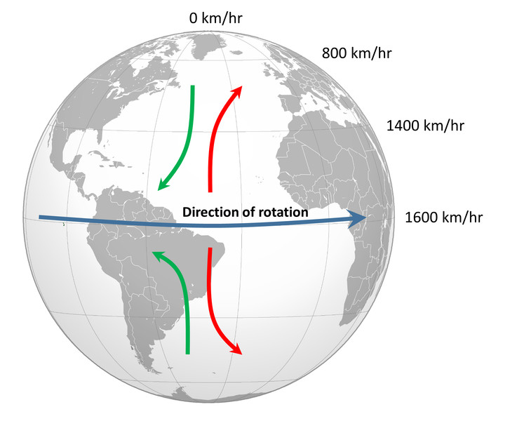
Coriolis effect on a rotating Earth
- In the Northern Hemisphere, air is deflected to the right
- In the Southern Hemisphere, air is deflected to the left
- The effect is weakest at the equator and stronger toward the poles
Be careful here. “Right” and “left” are relative to the air’s motion. It does not mean every wind in one hemisphere curves the same compass direction. The path depends on whether the air is moving toward the equator or toward the pole.
This is why winds don’t just blow straight north-south.
Why Global Wind Patterns Matter
Global wind patterns help keep Earth’s energy balanced by moving thermal energy away from low latitudes.
They also shape broad precipitation patterns:
- Equator tends to be warm and wet because rising air cools, condenses, and produces rain
- Around 30° tends to be dry because sinking air warms and lowers relative humidity
- Many deserts sit here, including the Sahara and Arabian deserts
- Around 60° has rising air and frequent weather activity
This model is idealized. It shows long-term average circulation, not daily local weather. Actual winds are modified by seasonal shifts in heating, continents and oceans, topography, land-water heating differences, short-term pressure systems, and El Niño/La Niña.
Key Takeaways
Global Wind Patterns
Large-scale, persistent atmospheric movements produced by unequal solar heating, pressure differences, and Coriolis deflection
Convection
Vertical movement in which warm, less-dense air rises and cooler, denser air sinks
Atmospheric Convection Cell
A large circulation loop of rising, sinking, and horizontally moving air that transports heat through the atmosphere
Pressure-Gradient Force
The force that drives air from areas of higher pressure toward areas of lower pressure
Three-Cell Circulation Model
The idealized global circulation model containing a Hadley, Ferrel, and polar cell in each hemisphere
Hadley Cell
Circulation from 0° to about 30° latitude, with air rising at the equator, sinking near 30°, and returning equatorward as trade winds
Ferrel Cell
Midlatitude circulation from about 30° to 60°, with surface air moving poleward as prevailing westerlies, rising near 60°, and returning aloft
Polar Cell
Circulation from about 60° to 90°, with cold air sinking at the poles, moving equatorward as polar easterlies, and rising near 60°.
Global Pressure Belts
Alternating pressure zones created by circulation: low at 0°, high near 30°, low near 60°, and high at 90°.
Intertropical Convergence Zone (ITCZ)
The warm, wet equatorial low-pressure zone where Northern and Southern Hemisphere trade winds converge and air rises
Doldrums
The weak and variable surface winds associated with the Intertropical Convergence Zone
Horse Latitudes
Subtropical high-pressure belts near 30° latitude characterized by descending air and often weak surface winds
Coriolis Effect
The apparent deflection of moving air to the right in the Northern Hemisphere and left in the Southern Hemisphere due to Earth’s rotation
Prevailing Wind
The direction from which wind most commonly blows in a region
Trade Winds
East-to-west surface winds from about 30° toward the equator: northeast trades in the Northern Hemisphere and southeast trades in the Southern Hemisphere
Prevailing Westerlies
West-to-east surface winds between about 30° and 60° latitude that blow from subtropical highs toward subpolar lows
Polar Easterlies
East-to-west surface winds between about 60° and the poles that blow from polar highs toward subpolar lows
Notes
Global Wind Patterns
Large-scale, persistent atmospheric movements produced by unequal solar heating, pressure differences, and Coriolis deflection
Convection
Vertical movement in which warm, less-dense air rises and cooler, denser air sinks
Atmospheric Convection Cell
A large circulation loop of rising, sinking, and horizontally moving air that transports heat through the atmosphere
Pressure-Gradient Force
The force that drives air from areas of higher pressure toward areas of lower pressure
Three-Cell Circulation Model
The idealized global circulation model containing a Hadley, Ferrel, and polar cell in each hemisphere
Hadley Cell
Circulation from 0° to about 30° latitude, with air rising at the equator, sinking near 30°, and returning equatorward as trade winds
Ferrel Cell
Midlatitude circulation from about 30° to 60°, with surface air moving poleward as prevailing westerlies, rising near 60°, and returning aloft
Polar Cell
Circulation from about 60° to 90°, with cold air sinking at the poles, moving equatorward as polar easterlies, and rising near 60°.
Global Pressure Belts
Alternating pressure zones created by circulation: low at 0°, high near 30°, low near 60°, and high at 90°.
Intertropical Convergence Zone (ITCZ)
The warm, wet equatorial low-pressure zone where Northern and Southern Hemisphere trade winds converge and air rises
Doldrums
The weak and variable surface winds associated with the Intertropical Convergence Zone
Horse Latitudes
Subtropical high-pressure belts near 30° latitude characterized by descending air and often weak surface winds
Coriolis Effect
The apparent deflection of moving air to the right in the Northern Hemisphere and left in the Southern Hemisphere due to Earth’s rotation
Prevailing Wind
The direction from which wind most commonly blows in a region
Trade Winds
East-to-west surface winds from about 30° toward the equator: northeast trades in the Northern Hemisphere and southeast trades in the Southern Hemisphere
Prevailing Westerlies
West-to-east surface winds between about 30° and 60° latitude that blow from subtropical highs toward subpolar lows
Polar Easterlies
East-to-west surface winds between about 60° and the poles that blow from polar highs toward subpolar lows
