Topic 4.8 Notes – Earth’s Geography and Climate
What Geographic Controls on Climate Are
Weather means short-term atmospheric conditions such as today’s temperature, wind, or rain. Climate means the long-term pattern of temperature and precipitation in a region.
The same factor can shape both. A mountain can cause one storm today, and over many years it can also help create a wet side and a dry side of a region.
Solar energy still drives atmospheric processes, but geography changes how heat and moisture are stored, moved, and distributed. That’s why two places at the same latitude can still have very different climates.
The main geographic controls to know are:
- Elevation and mountain topography: higher places are usually cooler, and mountains redirect air.
- Prevailing wind direction relative to mountains: wind direction tells you which side gets rising air and more rain.
- Proximity to oceans and large bodies of water: nearby water moderates temperature.
- Ocean surface temperature and currents: warm and cold water affect nearby air differently.
- Distribution of land and water: land heats and cools faster than water, so regions with more land behave differently from coastal ones.
Mountains, Elevation, and Rain Shadows
Mountains affect both temperature and precipitation.
Higher elevation usually means cooler temperatures because rising air enters lower pressure, expands, and cools. Mountains also force air upward. That process is orographic lifting.
The diagram below shows the basic pattern you need to recognize on exams.
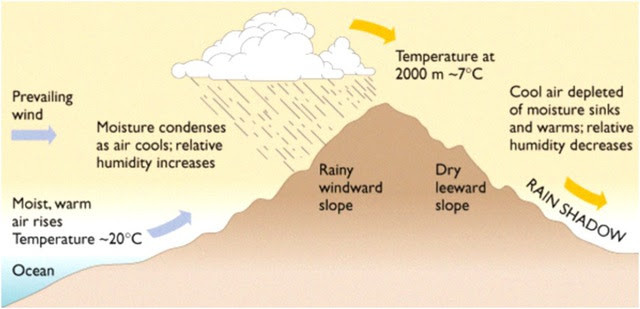
Rain shadow formation
Windward side
The windward side faces the incoming wind. Air rises there, cools, condenses, and often produces clouds and precipitation.
Leeward side
The leeward side is downwind of the mountain. Air descends there, gets compressed, warms, and becomes drier.
A common mistake is treating windward as “west side” or leeward as “east side.” Those labels depend on the prevailing wind, not compass direction.
A rain shadow is the dry region on the leeward side because the mountain caused the air to lose much of its moisture on the windward side.
How the Rain Shadow Effect Works
This is one of the most testable processes in the unit, so know the chain in order.
- Moist air approaches the mountain, often from an ocean or large lake.
- The mountain forces the air upward along the windward slope.
- As air rises, it expands and cools.
- Cooling causes condensation, cloud formation, and precipitation.
- The air mass loses moisture on the windward side.
- Drier air crosses the peak and descends the leeward slope.
- Descending air is compressed and warms.
- Warmer air has lower relative humidity, so precipitation becomes less likely.
- A relatively dry leeward region forms.
Two limits matter:
- Rain shadow means drier, not zero precipitation.
- The mountain does not literally “block rain.” It changes air movement, temperature, and moisture.
Examples you should know:
- Cascade Range: wet western slopes, drier eastern Washington and Oregon
- Sierra Nevada: wetter western slopes, dry Great Basin to the east
Oceans, Currents, and Coastal Climate
Water has high heat capacity, so it warms and cools more slowly than land. That gives coasts a more moderate climate.
Maritime influence
Coastal areas usually have:
- smaller daily and seasonal temperature ranges
- cooler conditions than inland areas during warm periods
- warmer conditions than inland areas during cool periods
Continental influence
Inland areas usually have:
- faster heating and cooling
- larger temperature extremes
- greater seasonal variation
Oceans also provide moisture through evaporation. Warmer surface water usually increases evaporation compared with colder water.
Warm currents
Warm currents can:
- warm nearby air and coasts
- reduce cold extremes
- add heat and moisture to the atmosphere
Cold currents
Cold currents can:
- cool nearby air and coasts
- reduce evaporation compared with warm water
- create cooler, more stable coastal conditions
So two coastal places at similar latitudes can still differ if one is beside a warm current and the other a cold one.
Reading Maps and Diagrams
Most questions here are visual. On a mountain cross section, read it in this order:
- look at the wind arrows
- identify the windward side first
- infer rising, cooling, clouds, and precipitation
- identify the leeward side
- infer descending, warming, and drier air
- label the dry downwind area as the rain shadow
On precipitation maps, wet on one mountain side and dry on the other suggests a rain shadow, especially if winds come from the wet side.
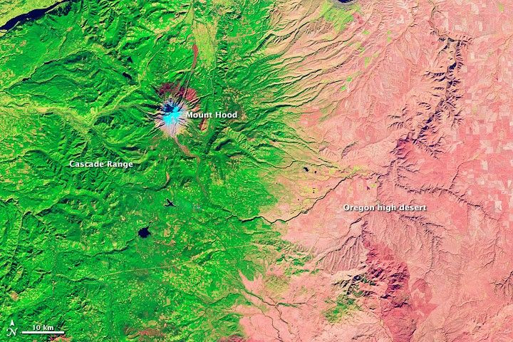
Cascade rain shadow near Mount Hood
This satellite image gives you that same pattern from above. The greener west side of the Cascade Range is wetter, and the pinker area to the east is the drier leeward side.
On ocean temperature or current maps:
- warm adjacent water suggests a warming coastal influence
- cold adjacent water suggests a cooling coastal influence
The strongest explanations combine factors. Ocean water supplies moisture and moderates temperature, winds carry air inland, mountains force uplift, rain falls on the windward side, and descending air dries the leeward side.
Key Takeaways
Weather
The short-term state of the atmosphere at a particular place and time, including temperature, precipitation, wind, humidity, clouds, and pressure
Climate
The long-term pattern and range of weather conditions in a region, including typical temperatures, precipitation, and weather frequency
Orographic Lifting
The forced rise of an air mass over a mountain or other elevated terrain, causing expansion and cooling that may produce precipitation
Windward Side
The side of a mountain that faces incoming wind, where air rises, cools, and commonly produces more precipitation
Leeward Side
The downwind side of a mountain, where descending air warms and becomes relatively dry
Rain Shadow (Rain Shadow Effect)
A relatively dry leeward region formed when air rises, cools, and loses moisture on a mountain’s windward side, then descends and warms
High Heat Capacity of Water
Water can absorb or release substantial thermal energy with relatively little temperature change, moderating nearby coastal temperatures
Maritime Climate
A climate strongly influenced by a nearby ocean, usually with milder temperatures and smaller daily and seasonal temperature ranges
Continental Climate
An inland climate with less ocean influence and generally greater daily and seasonal temperature variation
Ocean Currents
Movements of ocean water that redistribute heat; warm currents tend to warm nearby coasts, while cold currents tend to cool them
Notes
Weather
The short-term state of the atmosphere at a particular place and time, including temperature, precipitation, wind, humidity, clouds, and pressure
Climate
The long-term pattern and range of weather conditions in a region, including typical temperatures, precipitation, and weather frequency
Orographic Lifting
The forced rise of an air mass over a mountain or other elevated terrain, causing expansion and cooling that may produce precipitation
Windward Side
The side of a mountain that faces incoming wind, where air rises, cools, and commonly produces more precipitation
Leeward Side
The downwind side of a mountain, where descending air warms and becomes relatively dry
Rain Shadow (Rain Shadow Effect)
A relatively dry leeward region formed when air rises, cools, and loses moisture on a mountain’s windward side, then descends and warms
High Heat Capacity of Water
Water can absorb or release substantial thermal energy with relatively little temperature change, moderating nearby coastal temperatures
Maritime Climate
A climate strongly influenced by a nearby ocean, usually with milder temperatures and smaller daily and seasonal temperature ranges
Continental Climate
An inland climate with less ocean influence and generally greater daily and seasonal temperature variation
Ocean Currents
Movements of ocean water that redistribute heat; warm currents tend to warm nearby coasts, while cold currents tend to cool them
